


190-00592-06 Rev. A
Garmin G1000 Pilot’s Guide for the Diamond DA40/40F
301
HAZARD AVOIDANCE
SYSTEM
OVERVIEW
FLIGHT
INSTRUMENTS
EIS
AUDIO PANEL
& CNS
FLIGHT
MANAGEMENT
HAZARD
AVOIDANCE
AFCS
ADDITIONAL
FEATURES
APPENDICES INDEX
TURBULENCE
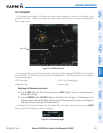
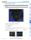
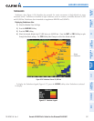
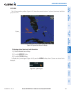
Turbulence data (Figure 6-36) identifies the potential for erratic movement of high-altitude air mass
associated winds. Turbulence is classified as light, moderate, severe or extreme, at altitudes between 21,000
and 45,000 feet.Turbulence data is intended to supplement AIRMETs and SIGMETs.
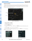
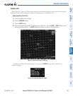
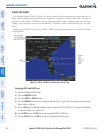
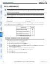
Displaying Turbulence data:
1) Select the Weather Data Link Page.
2) Press the
MORE WX
Softkey.
3) Press the
TURB
Softkey.
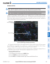
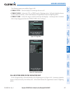
4) Select the desired altitude level: 21,000 feet up to 45,000 feet. Press the
NEXT
or
PREV
Softkey to cycle
through the altitude softkeys. The
TURB
Softkey label changes to reflect the altitude selected.
Figure 6-36 Turbulence Data at 21,000 Feet
Severe
Turbulence
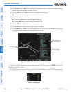
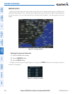
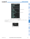
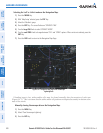
To display the Turbulence legend (Figure 6-37), press the
LEGEND
Softkey when Turbulence is selected
for display.
Figure 6-37 Turbulence Legend