


Garmin G1000 Pilot’s Guide for the Diamond DA40/40F
190-00592-06 Rev. A
288
HAZARD AVOIDANCE
SYSTEM
OVERVIEW
FLIGHT
INSTRUMENTS
EIS
AUDIO PANEL
& CNS
FLIGHT
MANAGEMENT
HAZARD
AVOIDANCE
AFCS
ADDITIONAL
FEATURES
APPENDICESINDEX
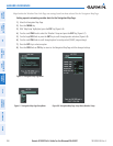
neXRaD li Mi tat io ns
NEXRAD radar images may have certain limitations:
•NEXRADbasereectivitydoesnotprovidesufcientinformationtodeterminecloudlayersorprecipitation
characteristics (wet hail vs. rain). For example, it is not possible to distinguish between wet snow, wet
hail, and rain.
•NEXRADbasereectivityissampledattheminimumantennaelevationangle.AnindividualNEXRAD
site cannot depict high altitude storms at close ranges. It has no information about storms directly over
the site.
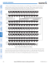
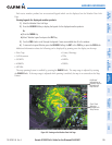
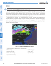
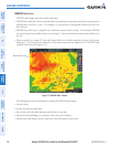
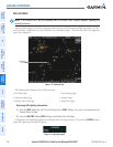
•Whenzoomedintoarangeof30nm,eachsquareblockonthedisplayrepresentsanareaoffoursquare
kilometers. The intensity level reflected by each square represents the
highest
level of NEXRAD data
sampled within the area (Figure 6-12).
Figure 6-12 NEXRAD Data - Zoomed
Block Area is 4 km
2
The following may cause abnormalities in displayed NEXRAD radar images:
•Groundclutter
•Strobesandspuriousradardata
•Sunstrobes(whentheradarantennapointsdirectlyatthesun)
•Interferencefrombuildingsormountains,whichmaycauseshadows
•Metallicdustfrommilitaryaircraft,whichcancausealterationsinradarscans