


Garmin G1000 Pilot’s Guide for the Diamond DA40/40F
190-00592-06 Rev. A262
FLIGHT MANAGEMENT
SYSTEM
OVERVIEW
FLIGHT
INSTRUMENTS
EIS
AUDIO PANEL
& CNS
FLIGHT
MANAGEMENT
HAZARD
AVOIDANCE
AFCS
ADDITIONAL
FEATURES
APPENDICESINDEX
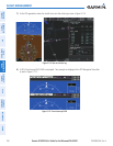
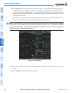
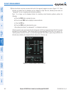
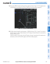
13) Note the altitude constraints associated with each of the approach waypoints as seen in Figure 5-127. These
altitudes are loaded from the database and are displayed as light blue text, indicating these values are
“designated” for use in computing vertical deviation guidance.
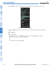
Note: To no longer use the displayed altitude for calculating vertical deviation guidance, perform the
following:
a) Press the FMS Knob to activate the cursor.
b) Turn the small FMS Knob to highlight the desired altitude.
c) Press the CLR Key.
d) Press the FMS Knob to deactivate the cursor.
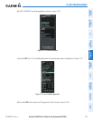
After making the altitude “non-designated”, it is displayed as white text.
Altitude constraint values associated with the Final Approach Fix (FAF) and waypoints beyond the FAF cannot be
designated for vertical guidance. These altitude values are always displayed as white text, as in Figure 5-127.
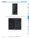
Vertical guidance from the FAF and on to the Missed Approach Point (MAP) is given using the WAAS GPS
altitude source, therefore, the displayed altitude values are for reference only.
Figure 5-127 Vertical Guidance is Active to the FAF