


190-00592-06 Rev. A
Garmin G1000 Pilot’s Guide for the Diamond DA40/40F
317
HAZARD AVOIDANCE
SYSTEM
OVERVIEW
FLIGHT
INSTRUMENTS
EIS
AUDIO PANEL
& CNS
FLIGHT
MANAGEMENT
HAZARD
AVOIDANCE
AFCS
ADDITIONAL
FEATURES
APPENDICES INDEX
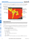
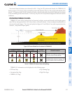
Terrain and obstacle databases are referenced to MSL. Using the GPS position and altitude, the TERRAIN-SVS
feature portrays a 3-D picture of the surrounding terrain and obstacles relative to the position and altitude of the
aircraft. GPS position and GPS-MSL altitude are used to calculate and predict the aircraft’s flight path in relation
to the surrounding terrain and obstacles. In this way, the pilot can view predicted dangerous terrain and obstacle
conditions.
DISPLAYING TERRAIN-SVS DATA
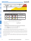
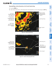
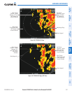
TERRAIN-SVS uses yellow (caution) and red (warning) to depict terrain and obstacles (with heights greater
than 200 feet above ground level, AGL) alerts relative to aircraft altitude. Colors are adjusted automatically as
the aircraft altitude changes. The colors and symbols in Figure 6-51 and Table 6-5 are used to represent terrain,
obstacles, and potential impact points.
Figure 6-58 Terrain Altitude/Color Correlation for TERRAIN-SVS
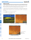
Unlighted Obstacle Lighted Obstacle
Potential
Impact Points
Obstacle Location
< 1000’ AGL > 1000’ AGL < 1000’ AGL > 1000’ AGL
WARNING: Red obstacle is above or within
100’ below current aircraft altitude
CAUTION: Yellow obstacle is between 100’
and 1000’ below current aircraft altitude
Table 6-5 TERRAIN-SVS Obstacle Colors and Symbology
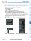
TERRAIN-SVS information can be displayed on the following maps:
•PFDInsetMap
•NavigationMapPage
•TERRAIN-SVSPage
•TripPlanningPage
•FlightPlanPages