


Garmin G1000 Pilot’s Guide for the Diamond DA40/40F
190-00592-06 Rev. A
314
HAZARD AVOIDANCE
SYSTEM
OVERVIEW
FLIGHT
INSTRUMENTS
EIS
AUDIO PANEL
& CNS
FLIGHT
MANAGEMENT
HAZARD
AVOIDANCE
AFCS
ADDITIONAL
FEATURES
APPENDICESINDEX
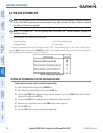
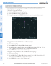
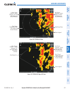
Additional information about obstacles can be displayed by panning over the display on the map. The map
panning feature is enabled by pressing the RANGE Knob. The map range is adjusted by turning the RANGE
Knob. If the map range is adjusted while panning is enabled, the map is re-centered on the Map Pointer.
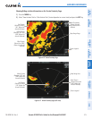
Figure 6-55 Terrain Information on the Navigation Map Page
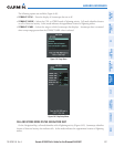
Additional Information
on Obstacle Selected
with Map Pointer
Yellow Terrain Area
(Between 100’ and
1000’ Below Aircraft
Altitude)
Red Lighted
Obstacles
(Above or Within
100’ Below Aircraft
Altitude)
Lighted Obstacle
Selected with Map
Pointer
Terrain Legend
Terrain Display
Enabled
Red Terrain Area
(Above or Within
100’ Below Aircraft
Altitude)
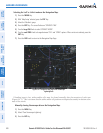
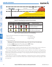
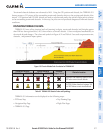
TERRAIN PROXIMITY PAGE
The Terrain Proximity Page is specialized to show terrain and obstacle data in relation to the aircraft’s current
altitude, without clutter from the basemap. Aviation data (airports, VORs, and other NAVAIDs) can be displayed
for reference.
Aircraft orientation on this map is always heading up unless there is no valid heading. Two views are available
relative to the position of the aircraft: the 360° default display and the radar-like ARC (120°) display. Map
range is adjustable with the RANGE Knob from 1 to 200 nm, as indicated by the map range rings (or arcs).
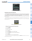
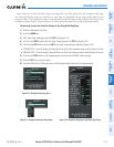
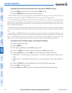
Displaying the Terrain Proximity Page:
1) Turn the large
FMS
Knob to select the Map Page Group.
2) Turn the small
FMS
Knob
to select the Terrain Proximity Page.
3) To change the view,
a) Press the
VIEW
Softkey.
b) Press the 360 or ARC Softkey to select the desired view.
Or:
a) Press the MENU Key.
b) Select ‘View 120º’ or ‘View 360º’ (choice dependent on current state) and press the ENT Key to change the view.