


Garmin G1000 Pilot’s Guide for the Diamond DA40/40F
190-00592-06 Rev. A
316
HAZARD AVOIDANCE
SYSTEM
OVERVIEW
FLIGHT
INSTRUMENTS
EIS
AUDIO PANEL
& CNS
FLIGHT
MANAGEMENT
HAZARD
AVOIDANCE
AFCS
ADDITIONAL
FEATURES
APPENDICESINDEX
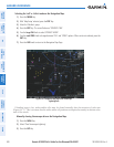
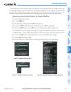
6.4 TERRAIN-SVS
WARNING: Do not use TERRAIN-SVS information for primary terrain avoidance. TERRAIN-SVS is intended
only to enhance situational awareness.
NOTE: Terrain data is not displayed when the aircraft latitude is greater than 75
°
North or 60
°
South.
NOTE: TERRAIN-SVS is standard when the Synthetic Vision System (SVS) option is installed. The TAWS
option will take precedence over TERRAIN-SVS.
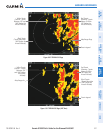
G1000 TERRAIN-SVS is a terrain awareness system available with the Synthetic Vision System (SVS). SVS
functionality is offered as an optional enhancement. Optional Terrain Awareness and Warning System (TAWS)
or standard TERRAIN-SVS is integrated within SVS to provide visual and auditory alerts to indicate the presence
of threatening terrain relevant to the projected flight path. For detailed information regarding SVS, refer to the
Synthetic Vision System (SVS) section of the G1000 Pilot’s Guide.
TERRAIN-SVS does not comply with TSO-C151b certification standards. It increases situational awareness and
aids in reducing controlled flight into terrain (CFIT). Do not confuse TERRAIN-SVS with Terrain Awareness and
Warning System (TAWS). TAWS is more sophisticated and robust, and it is TSO-C151b certified. Although the
terrain and obstacle color map displays are the same, TAWS uses more sophisticated algorithms to assess aircraft
distance from terrain and obstacles.
TERRAIN-SVS does not provide the following:
•PrematureDescentAlerting(PDA)
•ExcessiveDescentRate(EDR)
•NegativeClimbRate(NCR)
•Descentto500FeetCallout(DFC)
TERRAIN-SVS requires the following components to operate properly:
•Valid3-DGPSposition
•Validterrain/obstacledatabase
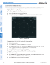
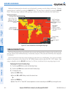
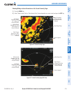
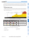
TERRAIN-SVS displays altitudes of terrain and obstructions relative to the aircraft position and altitude with
reference to a database that may contain inaccuracies. Terrain and obstructions are shown only if they are in the
database. Terrain and obstacle information should be used as an aid to situational awareness. They should never
be used to navigate or maneuver around terrain.
Note that all obstructions may not be available in the terrain and obstacle database. No terrain and obstacle
information is shown without a valid 3-D GPS position.
The G1000 GPS receiver provides the horizontal position and altitude. GPS altitude is derived from satellite
position. GPS altitude is then converted to a mean sea level (MSL)-based altitude (GPS-MSL altitude) and is used
to determine terrain and obstacle proximity. GPS-MSL altitude accuracy is affected by satellite geometry, but is not
subject to variations in pressure and temperature that normally affect pressure altitude sensors. GPS-MSL altitude
does not require local altimeter settings to determine MSL altitude. It is a widely-used MSL altitude source.