


190-00592-06 Rev. A
Garmin G1000 Pilot’s Guide for the Diamond DA40/40F
299
HAZARD AVOIDANCE
SYSTEM
OVERVIEW
FLIGHT
INSTRUMENTS
EIS
AUDIO PANEL
& CNS
FLIGHT
MANAGEMENT
HAZARD
AVOIDANCE
AFCS
ADDITIONAL
FEATURES
APPENDICES INDEX
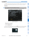
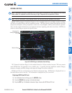
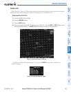
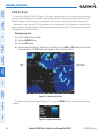
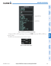
WINDS ALOFT
Winds Aloft data (Figure 6-32) shows the forecasted wind speed and direction at the surface and at selected
altitudes. Altitude can be displayed in 3,000-foot increments up to 42,000 feet MSL.
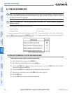
Displaying Winds Aloft data:
1) Select the Weather Data Link Page.
2) Press the
MORE WX
Softkey.
3) Press the
WIND
Softkey.
4) Select the desired altitude level: SFC (surface) up to 42,000 feet. Press the
NEXT
or
PREV
Softkey to cycle
through the altitude softkeys. The
WIND
Softkey label changes to reflect the altitude selected.
Figure 6-32 Winds Aloft Data at 27,000 Feet
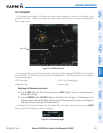
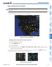
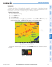
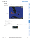
To display the Winds Aloft legend (Figure 6-33), press the
LEGEND
Softkey when Winds Aloft is
selected for display.
Figure 6-33 Winds Aloft Data with Legend