


Garmin G1000 Pilot’s Guide for the Diamond DA40/40F
190-00592-06 Rev. A26
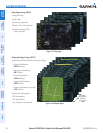
SYSTEM OVERVIEW
SYSTEM
OVERVIEW
FLIGHT
INSTRUMENTS
EIS
AUDIO PANEL
& CNS
FLIGHT
MANAGEMENT
HAZARD
AVOIDANCE
AFCS
ADDITIONAL
FEATURES
APPENDICESINDEX
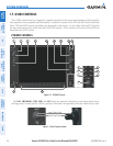
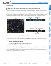
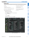
• MAP
Enables second-level Navigation Map Page softkeys
TRAFFIC
Displays/removes traffic information on Navigation Map Page
TOPO
Displays/removes topographical data (e.g., coastlines, terrain, rivers, lakes) on Navigation
Map Page
TERRAIN
Displays/removes terrain information on Navigation Map Page
AIRWAYS
Selects the desired display of Airways; cycles through:
AIRWY ON: All Airways displayed
AIRWY LO: Low Altitude (Victor) Airways displayed
AIRWY HI: High Altitude Airways (Jet Routes) displayed
AIRWAYS: Airways are not displayed
STRMSCP
Displays/removes Stormscope weather information on Inset Map (optional)
NEXRAD
Displays/removes NEXRAD weather/coverage on Navigation Map Page (optional)
XM LTNG
Displays/removes XM lightning information on Navigation Map Page (optional)
BACK
Returns to top-level softkeys
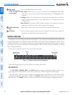
• DCLTR (3)
Selects desired amount of map detail; cycles through declutter levels:
DCLTR (No Declutter): All map features visible
DCLTR-1: Removes land data
DCLTR-2: Removes land and SUA data
DCLTR-3: Removes everything except the active flight plan
• SHW CHRT
Displays optional Flite Charts or Chart View charts (optional)
• CHKLIST
Displays the Checklist Page
DONE
Selects the highlighted checklist item
EXIT
Returns to the top-level softkeys
EMERGCY
Immediately accesses the emergency procedures