


190-00592-06 Rev. A
Garmin G1000 Pilot’s Guide for the Diamond DA40/40F
21
SYSTEM OVERVIEW
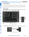
SYSTEM
OVERVIEW
FLIGHT
INSTRUMENTS
EIS
AUDIO PANEL
& CNS
FLIGHT
MANAGEMENT
HAZARD
AVOIDANCE
AFCS
ADDITIONAL
FEATURES
APPENDICES INDEX
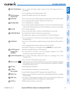
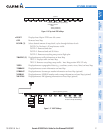
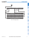
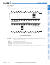
Figure 1-16 Top Level PFD Softkeys
INSET XPDR IDENT TMR/REF NRST ALERTSOBSPFD CDI
Press the CDI Softkey to cycle through
navigation sources:
- GPS
- NAV1 (VOR/LOC)
- NAV2 (VOR/LOC)
Press the BACK Softkey to
return to the top-level softkeys.
Press the IDENT or BACK
Softkey to return to the top-
level softkeys.
XPDR
STBY ON ALT VFR IDENT BACK ALERTSCODE
IDENT BACK
ALERTS
0 1 2 3 4 5 6 7 BKSP
GND
ADF/DME
(optional)
BACK
Press the OFF or BACK Softkey
to return to the top-level softkeys.
DCLTR
DCLTR-2
DCLTR-3
DCLTR-1
TOPO
ALERTS
NEXRAD
(optional)
TERRAIN
XM LTNG
(optional)
OFF
TRAFFIC
INSET
STRMSCP
(optional)
TRFC-2
TRFC-1
STD BARO
BACK
ALERTS
WIND
HSI FMT
PFD
Press the STD BARO or BACK
Softkey to return to the top-level
softkeys.
ALT UNIT
HPA BACK
ALERTS
METERS IN
DFLTS
Press the BRG1/BRG2
softkeys to display/remove
the Bearing Information
windows and cycle through
bearing sources:
- NAV1/NAV2
- GPS
- ADF
BACK
ALERTS
OPTN1 OPTN2 OPTN3
DME
(optional)
BACK
ALERTS
360 HSI
ARC HSI
BRG1
BRG2
OFF
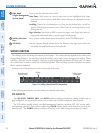
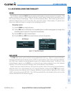
• INSET
Displays Inset Map in PFD lower left corner
OFF
Removes Inset Map
DCLTR (3)
Selects desired amount of map detail; cycles through declutter levels:
DCLTR (No Declutter): All map features visible
DCLTR-1: Removes land data
DCLTR-2: Removes land and SUA data
DCLTR-3: Removes everything except active flight plan
TRAFFIC (2)
Displays/removes traffic information on Inset Map
TRFC-1: Displays traffic on Inset Map.
TRFC-2: Removes everything except traffic. Inset Map position HDG UP only.
TOPO
Displays/removes topographical data (e.g., coastlines, terrain, rivers, lakes) on Inset Map
TERRAIN
Displays/removes terrain information on Inset Map
STRMSCP
Displays/removes Stormscope weather information on Inset Map (optional)
NEXRAD
Displays/removes NEXRAD weather and coverage information on Inset Map (optional)
XM LTNG
Displays/removes XM lightning information on Inset Map (optional)
Figure 1-17 INSET Softkeys
INSET XPDR IDENT TMR/REF NRST ALERTSOBSPFD CDI
Press the CDI Softkey to cycle through
navigation sources:
- GPS
- NAV1 (VOR/LOC)
- NAV2 (VOR/LOC)
Press the BACK Softkey to
return to the top-level softkeys.
Press the IDENT or BACK
Softkey to return to the top-
level softkeys.
XPDR
STBY ON ALT VFR IDENT BACK ALERTSCODE
IDENT BACK
ALERTS
0 1 2 3 4 5 6 7 BKSP
GND
ADF/DME
(optional)
BACK
Press the OFF or BACK Softkey
to return to the top-level softkeys.
DCLTR
DCLTR-2
DCLTR-3
DCLTR-1
TOPO
ALERTS
NEXRAD
(optional)
TERRAIN
XM LTNG
(optional)
OFF
TRAFFIC
INSET
STRMSCP
(optional)
TRFC-2
TRFC-1
STD BARO
BACK
ALERTS
WIND
HSI FMT
PFD
Press the STD BARO or BACK
Softkey to return to the top-level
softkeys.
ALT UNIT
HPA BACK
ALERTS
METERS IN
DFLTS
Press the BRG1/BRG2
softkeys to display/remove
the Bearing Information
windows and cycle through
bearing sources:
- NAV1/NAV2
- GPS
- ADF
BACK
ALERTS
OPTN1 OPTN2 OPTN3
DME
(optional)
BACK
ALERTS
360 HSI
ARC HSI
BRG1
BRG2
OFF