


Garmin G1000 Pilot’s Guide for the Diamond DA40/40F
190-00592-06 Rev. A
312
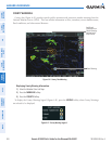
HAZARD AVOIDANCE
SYSTEM
OVERVIEW
FLIGHT
INSTRUMENTS
EIS
AUDIO PANEL
& CNS
FLIGHT
MANAGEMENT
HAZARD
AVOIDANCE
AFCS
ADDITIONAL
FEATURES
APPENDICESINDEX
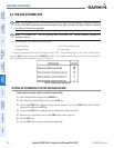
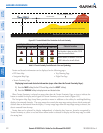
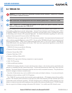
1000 ft
Aircraft Altitude
100 ft Threshold
Terrain Above Aircraft Altitude
Red terrain is above
or within 100 ft below
the aircraft altitude
Yellow terrain is between 100 ft and 1000 ft below the aircraft altitude
Black terrain is more than 1000 ft below the aircraft altitude
Figure 6-51 Terrain Altitude/Color Correlation for Terrain Proximity
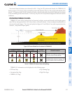
Unlighted Obstacle Lighted Obstacle
Obstacle Location
< 1000’ AGL > 1000’ AGL < 1000’ AGL > 1000’ AGL
Red obstacle is above or within 100 ft
below the aircraft altitude
Yellow obstacle is between 100 ft and
1000 ft below the aircraft altitude
Table 6-4 Terrain Proximity Terrain/Obstacle Colors and Symbology
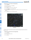
Terrain and obstacle information can be displayed on the following pages:
•PFDInsetMap
•NavigationMapPage
•TerrainProximityPage
•TripPlanningPage
•FlightPlanPage
Displaying terrain and obstacle information (maps other than the Terrain Proximity Page):
1) Press the MAP Softkey (for the PFD Inset Map, select the INSET Softkey).
2) Press the TERRAIN Softkey to display terrain and obstacle data.
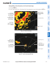
When Terrain Proximity is selected on maps other than the Terrain Proximity Page, an icon to indicate the
feature is enabled for display and a legend for Terrain Proximity colors are shown (Figure 6-55).
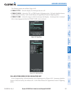
The Navigation Map Page Setup Menu provides a means in addition to the softkey for enabling/disabling
display of terrain and obstacles. The setup menu also controls the map range settings above which terrain and
obstacle data are decluttered from the display. If a map range larger than the map range setting is selected, the
data is removed from the map.
Terrain data can be selected for display independently of obstacle data; however, obstacles recognized by
Terrain Proximity as yellow or red are shown when terrain is selected for display and the map range is within
the setting limit.