


Garmin G1000 Pilot’s Guide for the Diamond DA40/40F
190-00592-06 Rev A408
ADDITIONAL FEATURES
SYSTEM
OVERVIEW
FLIGHT
INSTRUMENTS
EIS
AUDIO PANEL
& CNS
FLIGHT
MANAGEMENT
HAZARD
AVOIDANCE
AFCS
ADDITIONAL
FEATURES
APPENDICESINDEX
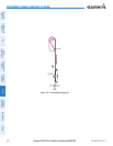
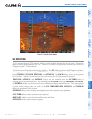
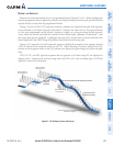
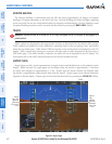
Figure 8-4 Programmed and Selected Altitude
Selected
Altitude
Programmed
Altitudes
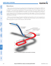
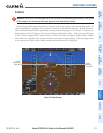
Pathways provide supplemental glidepath information on an active ILS, LPV, LNAV/VNAV, and some LNAV
approaches. Pathways are intended as an aid to situational awareness and should not be used independent
of the CDI, VDI, glide path indicator, and glide slope indicator. They are removed from the display when
the selected navigation information is not available. Pathways are not displayed beyond the active leg when
leg sequencing is suspended and are not displayed on any portion of the flight plan leg that would lead to
intercepting a leg in the wrong direction.
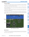
De P a R t u R e a n D en R o u t e
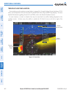
Prior to intercepting an active flight plan leg, pathways are displayed as a series of boxes with pointers at
each corner that point in the direction of the active waypoint. Pathways are not displayed for the first leg
of the flight plan if that segment is a Heading-to-Altitude leg. The first segment displaying pathways is the
first active GPS leg or active leg with a GPS overlay. If this leg of the flight plan route is outside the SVS
field of view, pathways will not be visible until the aircraft has turned toward this leg. While approaching
the center of the active leg and prescribed altitude, the number of pathway boxes decreases to a minimum
of four.
Pathways are displayed along the flight plan route at the highest of either the selected altitude or the
programmed altitude for the leg. Climb profiles cannot be displayed due to the variables associated with
aircraft performance. Flight plan legs requiring a climb are indicated by pathways displayed at a level above
the aircraft at the altitude selected or programmed.