


4-11
Rev 1
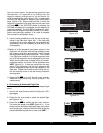
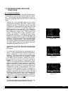
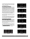
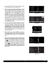
1.Select the FPL 0 page of the left side.
2.Press the left Cand then use the left outer knob to
position the cursor over the desired waypoint (figure 4-
40).
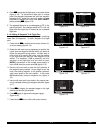
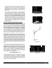
3.Press D. The waypoint page for the selected
waypoint in FPL 0 will be displayed on the right side
(figure 4-41).
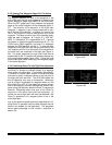
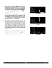
4.Press Eto approve the waypoint page. The Direct
To waypoint identifier in the active flight plan will now
be preceded by just an arrow (figure 4-42). The ∑
symbol is not displayed since there is no “from”
waypoint in the flight plan.
An alternative method is to use the Super NAV 5 page to
select the direct to waypoint. This is done by pulling out
on the right inner knob. With the inner knob out, it is pos-
sible to scan through the waypoints of the active flight
plan as described in section 3.9.7. When the desired
waypoint is highlighted, press Dand then E.
If for some reason it is desired to cancel the Direct To
operation prior to reaching the Direct To waypoint in order
to proceed along the flight plan leg, press D, then press
@, and then press E.
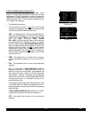
4.2.5 The Distance/Time Pages
As stated earlier, it is common to use the Distance/Time
pages in conjunction with flight plan operation. The
Distance/Time pages are specially designed to be most
useful when the active flight plan page (FPL 0) is dis-
played simultaneously on the left side.
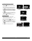
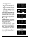
4.2.6 The Distance/Time 1 Page (D/T 1)
When the FPL 0 page is displayed on the left side and the
D/T 1 page is displayed on the right side, the distance
(DIS) and estimated time enroute (ETE) are displayed for
each of the active flight plan waypoints (figure 4-43). The
distance displayed is the cumulative distance from the air-
craft’s present position to each waypoint along the flight
plan route. The ETE is displayed in hours:minutes. If
Direct To operation is occurring to a waypoint that is not
in the active flight plan, then the D/T 1 page is blank when
the FPL 0 page is displayed on the left (figure 4-44).
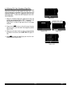
If a numbered flight plan page (FPL 1 though FPL 25) is
displayed on the left side, the distances displayed are
from the first waypoint in the flight plan and have nothing
to do with the aircraft’s present position. No ETEs are
then shown (figure 4-45).
; 1:KNEW |= 2 GPT D V
< 2:GPT |GULFPORT
3:SJI | L
4:CEW |109.00 2^E
5:MAI |N 30^24.40'
8:KPIE |W 89^04.60'
CRSR enr-leg ACT
Figure 4-40
5
DIRECT TO: | SJI D
< 2:GPT |SEMMES
SJI |17L/35R L H
4:CEW |115.30 5^E
5:MAI |N 30^43.55'
8:KPIE |W 88^21.56'
CRSR enr-leg ent VOR
Figure 4-41
1:KNEW | $=SJI
2:GPT |+++++Ê+++++
= 3:SJI |DIS 90.4nm
4:CEW |GS 180kt
5:MAI |ETE :30
8:KPIE |BRG 062^
FPL 0 enr-leg NAV 1
Figure 4-42
; 1:KNEW |DIS ETE
< 2:GPT | 34 :11
3:SJI | 76 :25
4:CEW |163 :54
5:MAI |243 1:21
8:KPIE |477 2:39
FPL 0 enr-leg D/T 1
Figure 4-43
|DIS ETE
1:KNEW |
2:GPT |
3:SJI |
4:CEW |
8:KPIE |
FPL 0 enr-leg D/T 1
Figure 4-44
USE? INVRT?|DIS ETE
1:KMKC |
2:BUM | 51
3:OSW |126
4:TUL |190
7:KDAL |432
FPL 6 enr-leg D/T 1
Figure 4-45