


5-7
Rev 1
5.2 ADVISORY VNAV OPERATION
The KLN 90B’s vertical navigation feature (VNAV)
allows you to program a descent or ascent path, and
then provides you with an advisory altitude to fly that will
provide guidance along the vertical path. For example,
you can program the VNAV to provide descent guidance
so that you arrive at your active waypoint or a waypoint
in the active flight plan at an altitude that you specify.
The KLN 90B will alert you of when to start the descent,
and display the advisory altitudes to fly throughout the
descent.
5.2.1 VNAV For Direct To Operation
The Navigation 4 (NAV 4)page is used to program the
KLN 90B for vertical navigation. The following example
will be used to illustrate how to use the VNAV feature.
You are using the KLN 90B to fly direct to your destina-
tion airport, Dubuque Municipal airport (KDBQ) located
in Dubuque, Iowa. You are presently about 65 nm West
of Dubuque, flying at 7500 feet MSL (figure 5-21). You
desire to use the VNAV to provide vertical guidance to
Dubuque’s traffic pattern altitude of 1900 feet MSL.
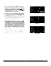
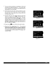
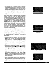
1.Select the NAV 4 page on either side of the screen
(figure 5-22). You can select the NAV 4 page either
by using the knobs or by pressing Ato bring up the
NAV 4 page on the right side and the ALT page on
the left. The aircraft’s actual altitude is displayed in
the INDfield. If the displayed altitude is incorrect it is
probably because you have not recently updated the
KLN 90B’s altimeter baro setting on the ALT page
(see section 3.15).
NOTE: There may be some difference (less than 100
feet) between the indicated altitude (IND) and the air-
craft’s actual altitude if the altitude input to the KLN 90B
is from an altitude encoder because these encoders
only provide altitude in 100 foot increments.
The identifier for the active waypoint (KDBQ) is auto-
matically displayed on the NAV 4 page. Prior to pro-
gramming a VNAV operation, the top of the page dis-
plays that the VNAV is inactive (VNV INACTV).
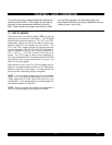
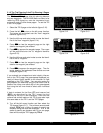
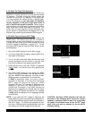
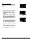
2.Press the appropriate Cbutton to turn on the cur-
sor function if it is not already on (figure 5-23).
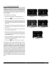
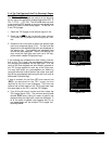
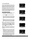
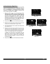
3.Enter the desired altitude of 1900 feet in the SEL
field. The outer knob is used to move the cursor and
the inner knob is used to select the digits. The alti-
tude may be entered in 100 foot increments
(figure 5-24).
NOTE: If the KLN 90B does not have an altitude input,
the IND and SEL fields will be labeled FR (from) and TO
respectively. The aircraft’s present altitude must be
entered into the FR field and the desired altitude into the
TO field.
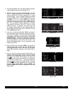
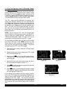
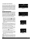
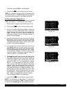
Figure 5-21
$=KDBQ
DIS 64.8nm ETE :27
GS 145kt BRG 094^
NAV 1 enr-leg NAV 1
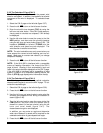
Figure 5-22
$=KDBQ |VNV INACTV
+++++Â+++++|
DIS 64.8nm|IND 07500ft
GS 145kt|SEL:00000ft
ETE :27|KDBQ :-00nm
BRG 094^|ANGLE:-0.8^
NAV 1 enr-leg NAV 4
Figure 5-23
|VNV INACTV
|
|IND 07500ft
|SEL:00000ft
|KDBQ :-00nm
|ANGLE:-0.8^
CRSR
Figure 5-24
|VNV INACTV
|
|IND 07500ft
|SEL:01900ft
|KDBQ :-00nm
|ANGLE:-0.8^
CRSR