


3-31
Rev 1
3.9 THE NAVIGATION PAGES
As you would expect, the NAV (navigation) pages contain
information relating specifically to the KLN 90B’s naviga-
tion capabilities. The KLN 90B has five NAV pages.
Unlike any other pages, these pages may be selected
and viewed on both the left and right sides of the screen.
The procedure for selecting specific pages, including the
NAV pages, was described in section 3.4.1, “Page
Selection.” This section will cover all NAV pages except
for the NAV 4 page (Vertical Navigation) which is
explained in section 5.2.
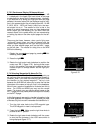
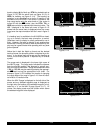
3.9.1 The Navigation 1 Page (NAV 1)
A NAV 1 page is shown in figure 3-97. A NAV 1 page
displays the following information:
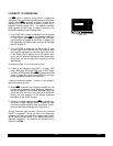
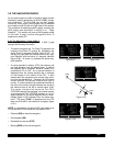
• The active navigation leg. For Direct To operation this
consists of the Direct To symbol, d, followed by the
active Direct To waypoint identifier (figure 3-97). For
the leg of a flight plan this consists of the “from” way-
point identifier and the active “to” waypoint identifier
(figure 3-98). An arrow (>) precedes the active way-
point identifier.
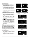
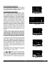
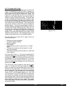
• A course deviation indicator (CDI) that displays left
and right deviation from the desired track. A vertical
bar operates like a navigation deviation needle on a
conventional CDI or HSI. An on-course indication is
displayed when the vertical deviation bar is centered
on the triangle in the middle of the CDI. In both
modes each dot represents one nautical mile devia-
tion from the desired track. Therefore, the CDI shows
course deviation five nautical miles left and right of
course. A vertical deviation bar positioned two dots to
the right of the center triangle indicates the aircraft is
two nautical miles to the left of course (figure 3-99).
The center triangle also serves as the CDI’s
TO/FROM indicator and operates in the same manner
as a conventional CDI TO/FROM indicator; an “up” tri-
angle indicates “to” the active waypoint while a “down”
triangle (figure 3-100) indicates “from” the active way-
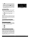
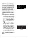
point. The word “FLAG” is displayed over the CDI
when the KLN 90B is not usable for navigation (figure
3-101).
NOTE: It is possible to change the CDI scale factor to be
0.2 nm per dot or 0.06 nm per dot. See section 5.9.8.
• Distance (DIS)to the active waypoint.
• Groundspeed (GS)
• Estimated time enroute (ETE)
• Bearing (BRG)to the active waypoint.
KHPN =KOSH |
+++++i+fl+++|
DIS 683nm|
GS 193kt|
ETE 3:34|
BRG 303^|
NAV 1
KHPN
KOSH
2 NM
Figure 3-99
=KOSH |
+++++Ï+++++|
DIS 18nm|
GS 193kt|
ETE :06|
BRG 123^|
NAV 1
Figure 3-100
|
++F L A G++|
DIS --.-nm|
GS ---kt|
ETE --:--|
BRG ---^|
NAV 1
Figure 3-101
$=KOSH |
+++++Ê+++++|
DIS 683nm|
GS 193kt|
ETE 3:34|
BRG 303^|
NAV 1
Figure 3-97
KHPN =KOSH |
+++++Ê+++++|
DIS 683nm|
GS 193kt|
ETE 3:34|
BRG 303^|
NAV 1
Figure 3-98