


3-24
Rev 1
3.7.3.2 Continuous Display Of Nearest Airport
When the nearest airport page is initially displayed, “NR
1” is displayed in the upper right hand corner of the page
to designate this airport as the nearest airport. However,
if you continue to fly along your flight plan with this page
selected, the same airport will be displayed and its posi-
tion in the nearest airport list will change from NR 1 to NR
2, NR 3, NR 4 ... NR 9 until finally it won’t be in the near-
est airport list at all. The reason for this is that in the
event of an actual emergency once you have determined
which airport you are heading for, you don’t want the
nearest airport list to update while you are maneuvering
or looking up data on the other airport pages for that air-
port.
There may be times, however, when you’re flying over
“unfriendly” terrain when you wish to always have the
nearest airport displayed on the right side of the screen
while you view another page, such as the NAV 1 page,
on the left side. The means for doing this on the KLN
90B is the following:
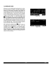
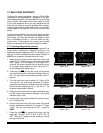
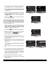
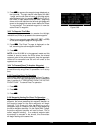
1. Display the nearest airport page by pressing M fol-
lowed by pressing E.
2. Press the right C.
3. Rotate the right outer knob clockwise to position the
cursor over “NR 1” (figure 3-76). As long as the cursor
is left in this position, this page will update so that the
nearest airport is always shown as the flight pro-
gresses.
3.7.4 Selecting Waypoints By Name Or City
When you know the identifier of the desired waypoint you
will use one of the two methods just described to select it.
However, what if you know the name but you don’t know
the identifier or your desired waypoint? You’re in luck
because the KLN 90B will allow you to enter the first few
characters of the name to help you find it in the database.
We will use a couple of examples to illustrate how this is
done. For VORs and NDBs you may use the navaid
name. For airports, you may use the airport name on the
APT 1 page or the city name (where the airport is located)
on the APT 2 page.
In this first example we want to view the information in the
KLN 90B database for Napoleon VOR (located just East
of Kansas City) but we don’t remember the identifier for it.
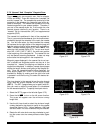
1. Turn the right outer knob to the VOR waypoint type.
The VOR waypoint in view is not important.
2. Press the right C. Make sure the right inner knob is
pushed to the “in” position.
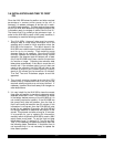
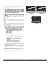
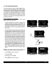
3. Rotate the right outer knob clockwise until the cursor
is over the first character in the VOR name which is
being displayed (figure 3-77).
| KHPN nr 1
|WESTCHESTER
| CO
| 6548' HRD
|L 003^t]
| 04.1nm
CRSR
Figure 3-76
| BMI D
|BLOOMINGTON
|
|108.20 3^E
|N 40^28.85'
|W 88^55.87'
CRSR
Figure 3-77