


5-19
Rev 1
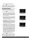
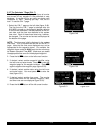
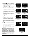
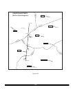
2.Use the right Cand the right inner and outer
knobs in the manner previously described in section
5.4.1, “Creating An Airport User Waypoint”, to select
the waypoint identifier (figure 5-68).
3.Rotate the right outer knob to position the cursor
over USER POS?and press E. A user waypoint
page will appear with the identifier at the top with the
cursor over a dashed latitude field (figure 5-69).
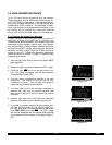
4.Turn the right outer knob counterclockwise to posi-
tion the cursor over the dashes to the right of REF
(figure 5-70).
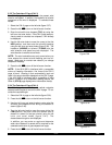
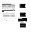
5.Rotate the right inner knob to select the first charac-
ter of an identifier for a “reference waypoint”. This
waypoint may be any existing waypoint.
6.Use the right outer knob to position the cursor, and
the right inner knob to select the characters so that
the entire identifier for the reference waypoint is dis-
played (figure 5-71).
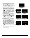
7.Press Eto see the waypoint page for the reference
waypoint just entered.
8.Press Eagain to approve this waypoint page. The
waypoint page being created will return with the cur-
sor over the dashes to the right of RAD(figure 5-
72).
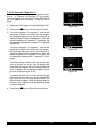
9.Use the right inner and outer knobs to select the
radial (from the reference waypoint). The radial may
be selected to the nearest tenth of a degree (figure
5-73).
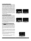
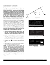
10.Press E. The cursor will move to the dashes to
the right of DIS.
11.Use the right inner and outer knob to select the dis-
tance. The distance may be selected to the nearest
tenth of a nautical mile (figure 5-74).
12.Press E. The latitude and longitude is calculated
and displayed. The user waypoint is now defined
(figure 5-75).
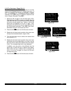
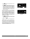
NOTE: Entering the reference waypoint, radial, and dis-
tance is done only to define the user waypoint’s latitude
and longitude position. The reference waypoint, radial,
and distance are not stored as part of the user waypoint.
As soon as another page is viewed on the right side,
these parameters are lost. If the waypoint page for a
user-defined intersection or Supplemental waypoint is
viewed later on, it will display the radial and distance
from the VOR nearest the user-defined waypoint (figure
5-76). The original reference waypoint may be re-
entered at any time.
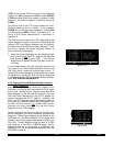
Figure 5-68
| INT15
|
|CREATE NEW
|WPT AT:
|USER POS?
|PRES POS?
CRSR
Figure 5-69
| INT15
|REF: !!!!!
|RAD: !!!.!^
|DIS:!!!.!nm
|! !!^!!.!!'
|!!!!^!!.!!'
CRSR
Figure 5-70
| INT15
|REF: !!!!!
|RAD: !!!.!^
|DIS:!!!.!nm
|! !!^!!.!!'
|!!!!^!!.!!'
CRSR
Figure 5-71
| INT15
|REF: ORD
|RAD: !!!.!^
|DIS:!!!.!nm
|! !!^!!.!!'
|!!!!^!!.!!'
CRSR
Figure 5-72
| INT15
|REF: ORD
|RAD: !!!.!^
|DIS: !!.!nm
|! !!^!!.!!'
|! !!^!!.!!'
CRSR
Figure 5-73
| INT15
|REF: ORD
|RAD: 234.8^
|DIS:!!!.!nm
|! !!^!!.!!'
|!!!!^!!.!!'
CRSR
Figure 5-74
| INT15
|REF: ORD
|RAD: 234.8^
|DIS:048.1nm
|! !!^!!.!!'
|!!!!^!!.!!'
CRSR
Figure 5-75
| INT15
|REF: ORD
|RAD: 234.8^
|DIS: 48.1nm
|N 41^32.77'
|W 88^47.95'
INT
Figure 5-76
| INT15
|REF: JOT
|RAD: 268.1^
|DIS: 21.6nm
|N 41^32.77'
|W 88^47.95'
INT