


4-16
Rev 1
4.3.1 Pre-Departure
1.After turn-on and approval of the Self Test and
Database pages, the APT 4 page (airport communica-
tion frequencies) for KNEWis displayed on the right
side of the screen. Viewing the APT 4 page, you set
up the COMMs for ATIS, Clearance Delivery, Ground,
and Tower.
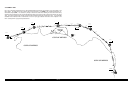
2.You create the flight plan on the FPL 4 page exactly
as described for this route in section 4.1.1. The flight
plan route is from KNEW, to GPT(Gulfport VOR), to
SJI(Semmes VOR), to CEW(Crestview VOR), to
MAI(Marianna VOR), to TLH(Tallahassee VOR), to
CTY(Cross City VOR), to KPIE.
3.The flight plan is now activated (made FPL 0) as
described in section 4.1.2.
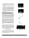
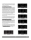
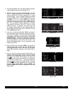
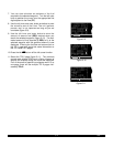
4.Until the KLN 90B reaches a NAV ready status, there
is no ∑symbol to indicate the active flight plan leg on
the FPL 0 page and no distances displayed on the
D/T 1 page (figure 4-56).
5.Shortly, the KLN 90B reaches a NAV ready status (fig-
ure 4-57). You see that the distance is 496 NM to St.
Petersburg/Clearwater along the flight plan route. The
active leg of the flight plan is KNEW- GPTand is so
indicated on the FPL 0 page 2 with the ∑symbol.
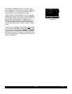
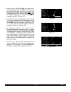
6.You briefly view the D/T 3 page to determine that the
desired track to the first waypoint, GPT, is 63 degrees
(figure 4-58).
4.3.2 Enroute
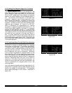
1.After departure from runway 18R at Lakefront airport,
you receive radar vectors out of the New Orleans
Class B airspace. Finally, you are cleared direct
Gulfport. At this point you are slightly South of the
original course because of the radar vectors. Since
you are displaying the D/T 1 page (a non-waypoint
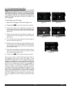
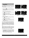
page) on the right side, to proceed direct to the active
waypoint in the flight plan you press D, and then
press E(figure 4-59). Remember that if a waypoint
page would have been displayed on the right side
when Dwas pressed, the Direct To page would
have contained that waypoint’s identifier, not the
active waypoint’s identifier). You reselect the D/T 1
page on the right side (figure 4-60). Since you are still
climbing at 120 knots, the ETEs are not representative
of what they will be when you level off at cruise speed.
2.Approaching Gulfport, the arrow adjacent to GPT
begins flashing. This waypoint alert notification begins
approximately 20 seconds before the time to start
your turn to join the second flight plan leg, GPT - SJI.
You briefly view the D/T 3 page to see that the next
desired track is 61 degrees.
|DIS ETE
1:KNEW |
2:GPT |---- --:--
3:SJI |---- --:--
4:CEW |---- --:--
8:KPIE |---- --:--
FPL 0 enr-leg D/T 1
Figure 4-56
; 1:KNEW |DIS ETE
< 2:GPT | 54 --:--
3:SJI | 95 --:--
4:CEW |182 --:--
5:MAI |263 --:--
8:KPIE |496 --:--
FPL 0 enr-leg D/T 1
Figure 4-57
; 1:KNEW |DIS DTK
< 2:GPT | 54 063^
3:SJI | 95 061^
4:CEW |182 085^
5:MAI |263 092^
8:KPIE |496 172^
FPL 0 enr-leg D/T 3
Figure 4-58
1:KNEW | $=GPT
= 2:GPT |+++++Ê+++++
3:SJI |DIS 41.1nm
4:CEW |GS 120kt
5:MAI |ETE :20
8:KPIE |BRG 054^
FPL 0 enr-leg NAV 1
Figure 4-59
1:KNEW |DIS ETE
= 2:GPT | 41 :20
3:SJI | 83 :41
4:CEW |170 1:25
5:MAI |250 2:05
8:KPIE |484 4:02
FPL 0 enr-leg D/T 1
Figure 4-60