


3-43
Rev 1
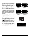
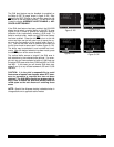
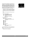
3.11.3 The Airport 2 Page (APT 2)
See figure 3-135.
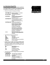
• Airport identifier. An arrow precedes the identifier if it
is the active waypoint.
• The city where the airport is located.
• The state if the airport is located in the United States,
the Province if located in Canada, or the country out-
side the United States and Canada. A listing of the
abbreviations used for States, Provinces, and coun-
tries is contained in Appendix D.
• Airport elevation. The elevation is rounded to the
nearest 10 feet.
• Time in relationship to UTC (Zulu). Z-05, for example,
indicates local standard time is five hours behind UTC
time. If the airport is located in an area which
observes daylight savings time, the information in
parentheses shows the daylight savings time in rela-
tionship to UTC.
• Instrument approach information.
ILS - airport has an ILS approach.
MLS - airport has an MLS approach.
ILS/MLS- airport has ILS and MLS approaches.
NP APR- airport has a non-precision approach
and no ILS or MLS.
NO APR- airport does not have an instrument
approach.
• The symbol (R) designates that the airport is serviced
by an Approach/Departure control facility having radar
capability. If you are on an instrument flight plan, you
know whether to expect vectors to the final approach
course or whether you will have to do your own transi-
tion. If you are VFR, you know whether or not the
Approach/Departure control is capable of providing
separation advisories.
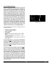
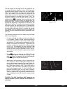
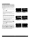
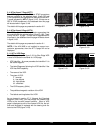
3.11.4 The Airport 3 Page (APT 3)
The function of the APT 3 page is to display runway infor-
mation for the selected airport. For many airports the first
APT 3 page depicts a North up runway diagram for the
airport as shown in figure 3-136 for KORL.
NOTE: This runway diagram is present only for those air-
ports where Jeppesen’s data contains the position of the
runway thresholds
.
|
|
|
|
|
|
APT[3
13
31
25
07
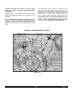
Figure 3-136
|=KORL
|ORLANDO FL
|
|ELV 110ft
|Z-05(-04DT)
|ILS (R)
APT 2
Figure 3-135