


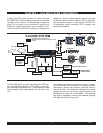

2-2
Rev 1
only for airports in the primary area of the database.
Intersections, air route traffic control center data, flight
service station frequencies, and special use airspace are
also provided only for the primary area.
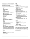
The following is a list of the KLN 90B database contents:
*AIRPORTS
• Identifier
• Name
• City, State or Country
• Type (public or military)
• Latitude and Longitude
• Elevation
• Approach indicator for precision, non-precision or no
instrument approach at airport
• Radar approach/departure environment indicator
• Whether airport underlies CL B, TRSA, CL C, CTA, or
TMA
• Time relative to UTC (Zulu)
• Communication frequencies (VHF and HF):
ATIS
Clearance delivery
Tower
Ground control
Unicom
Multicom
Approach (IFR)
Departure (IFR)
Class B, Class C, TRSA, CTA, TMA (VFR)
Center (when used for approach)
Arrival
Radar
Director
Radio
AWOS (automatic weather observing station)
AAS (aeronautical advisory service)
ATF (Aerodrome traffic frequency)
CTAF (common traffic advisory frequency)
MF (mandatory frequency)
Ramp control
PCL (pilot-controlled lights)
• Runway data (designation, length, surface, lighting,
traffic pattern direction)
• Airport Services (fuel, oxygen, customs, indicator for
presence of a landing fee)
• Airport Comments (user may manually enter remarks
of up to 33 characters at any 100 airports in database)
VORs
• Identifier
• Name
• Frequency
• DME indicator
• Class (high altitude, low altitude, terminal, undefined)
• Latitude and Longitude
• Magnetic variation
NDBs
• Identifier
• Name
• Frequency
• Latitude and Longitude
(Note - Outer Compass Locators are stored as
Intersections)
*INTERSECTIONS (low altitude, high altitude, SID/STAR,
approach, and outer markers)
• Identifier
• Latitude and Longitude
*SID/STAR/Approach Procedures
• All compatible pilot-nav SID/STAR procedures
• Non-precision approaches (except localizer, LDA
(Localizer Directional Aid), SDF (Simplified Directional
Facility)) approved for overlay use. Includes all public
GPS only approaches.
MISCELLANEOUS
• *Air Route Traffic Control Center (ARTCCs and FIRs)
boundaries and frequencies (VHF and HF)
• *Flight Service Stations (Location of points of
communication and associated frequencies - VHF
and HF)
• Minimum Safe Altitudes
• *Special Use Airspace boundaries (Prohibited,
Restricted, Warning, Alert, MOA, Class B, TRSA,
Class C, CTA, TMA)
250 USER DEFINED WAYPOINTS
• Identifier
• Latitude and Longitude
• Additional data depending on how user defines
waypoint:
User airports (elevation and surface of longest
runway)
User VOR (frequency and magnetic variation)
User NDB (frequency)
And you think your telephone directory has a lot of
information!
* Items indicated with asterisk are included in the primary
database coverage area, but not in secondary coverage
area. The exception is that airports in primary coverage
area include those public and military bases having a run-
way at least 1000 feet in length. Airports in secondary
coverage area are those having a hard surface runway at
least 3000 feet in length.