


4-18
Rev 1
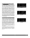
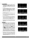
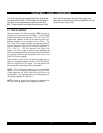
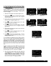
8.When you are 20 NM West of MAI, you decide to pro-
ceed direct to Cross City VOR (CTY). To do this from
the Super NAV 5 page, you pull out the right inner
knob and scan through the active flight plan until CTY
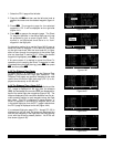
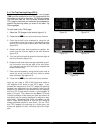
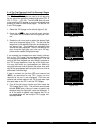
is displayed (figure 4-66). Next, you press Dto view
the waypoint page for CTY, and then press Eto
navigate directly to CTY (figure 4-67).
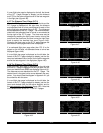
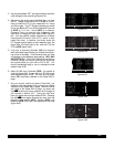
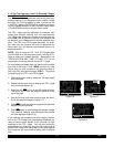
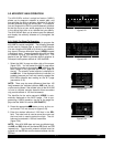
9.Over CTYyou check the weather and determine that
it is currently marginal VFR at St. Petersburg and that
you may have to shoot the ILS 17L approach. You
add CAPOK, the outer compass locator for runway
17L, to your flight plan using the same procedure as
described in section 4.1.3 (figure 4-68).
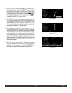
10.To prepare yourself for the arrival into St.
Petersburg/Clearwater International airport, you famil-
iarize yourself with the database information for KPIE.
The easiest way to do this is to select the ACT pages
on the right side. If necessary, scan the waypoints in
the active flight plan by first pulling the right inner knob
to the “out” position. Then, rotate it to view the
desired waypoint. For KPIE, push the right inner knob
back to the “in” position and rotate it to display the
eight airport pages.
11.By the time you get to the St. Petersburg terminal
area, the weather has cleared so that an instrument
approach is not necessary. You delete CAPOKfrom
the flight plan exactly as described in section 4.1.4.
18.9 oq
MAI |
xy-«} |
180 uv
áà0:06|
ûü093^|
†ü093^|120 CTY
MAI
TLH
CTY
Figure 4-66
144 oq
CTY |
xy-«} |
180 uv
áà0:48|
ûü120^|
†ü121^|160
CTY
Figure 4-67
4:CEW |DIS ETE
5:MAI |
6:TLH |
; 7:CTY |
< 8:CAPOK | 97 :32
9:KPIE |102 :34
FPL 0 enr-leg D/T 1
Figure 4-68