


3-38
Rev 1
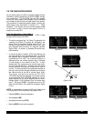
The last surprise for this page is that it is possible for you
to change the active waypoint to any of the flight plan
waypoints without having to leave this very useful page.
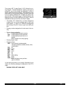
This is done by pulling on the right inner knob to place it
in the “out” position. This will create a “window” at the
bottom right corner of the display that will initially contain
the active waypoint in reverse video (figure 3-123). The
waypoint contained in this “window” will be the default
waypoint when Dis pressed. By turning the right inner
knob it is possible to scan through the waypoints of the
active flight plan. Turning the knob clockwise will scan
through the waypoints in sequence until the end of the
flight plan is reached. Turning the knob counter-clockwise
will scan through the active flight plan in reverse order
until the beginning of the flight plan is reached. Pushing
the right inner knob back to the “in” position will remove
the “window” from the graphics portion of the display. An
example of how to use this technique is presented in sec-
tion 4.3.2.
The following operational hints will make using the Super
NAV 5 more enjoyable.
• It is easy to clutter the display with so much data that
it is unusable. Select a range scale that allows an
uncluttered presentation of the chosen VORs, NDBs,
and airports. Or, select another combination of VORs,
NDBs, and airports from the menu. Experiment and
continue to make new selections for different phases
of your trip. For example, you may find that in the
enroute part of the flight selecting high altitude VORs
provide you with enough information, while in the ter-
minal area you select a smaller range scale and select
more items.
• Press @to instantly declutter the VOR, NDB, and
airport selections from the graphics display. Flight
plan and Direct To waypoints will still be displayed.
Press @again to restore the selections.
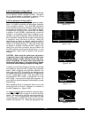
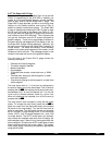
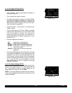
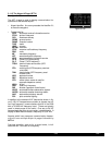
• While taxiing on the airport or flying in the traffic pat-
tern, select the 1 NMor 2 NMscale to display the air-
port runway diagram instead of the usual airport dia-
mond symbol. All runway designations are shown on
the 1 NMscales (figure 3-124). If the 2 NM scale is
selected, then the runway designations are shown
only for the longest runway. If your KLN 90B is not
provided a heading input you may wish to select a
North up display while the aircraft is on the airport
since an actual track up graphics presentation can
only be displayed when the aircraft is moving at least
2 knots.
CAUTION: The NAV 5 and Super NAV 5 pages do not
display weather, terrain, special use airspace, or
other data.
355 oq
KTIK |
xy-«} |
0 uv
áà-\--|
ûü039^|
†ü---^|1
14R
32R
32L
KRND
i
j
Figure 3-124
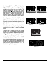
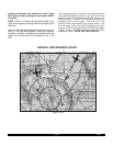
LRP
ETX
RAV
BZJ
LQX
AB
APG
9.0 oq
LRP |
xy-«} |
200 uv
áà0:03|
ûü113^|
†ü113^|40 LRP
Figure 3-123