


5-33
Rev 1
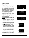
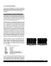
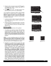
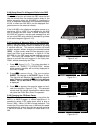
2.Rotate the left inner knob to select the MOD page for
the desired mode: MOD 1 to select Leg or MOD 2 to
select OBS (figure 5-108).
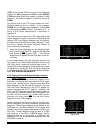
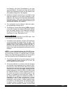
3.Press E(figure 5-109). The mode change is com-
plete and you may return to any desired page.
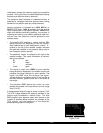
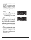
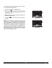
It is not possible to change the mode by using the MOD
pages when an external switch is installed. If you
attempt to change the mode by using the MOD pages
they will appear as shown in figure 5-110. Use the
following procedure when an external LEG/OBS switch
is installed in the aircraft:
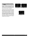
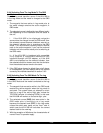
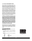
1.Locate the external switch in the panel of the aircraft.
An example of an external switch annunciator is
shown in figure 5-111.
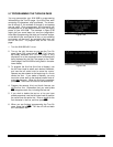
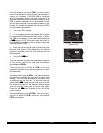
2.Change the position of the external switch. In the case
of the combination switch/annunciator all that you
have to do is press the unit and it will switch modes
(figure 5-112).
5.9.2 The Leg Mode
The following are characteristics of the Leg Mode:
1.The default course deviation indicator (CDI) sensitivity
is plus and minus five nautical miles, full scale. This
applies to the CDI on the NAV 1 page as well as any
external CDIs or HSIs interfaced to the KLN 90B. If
the CDI or HSI has five dots left and right of the center
position, then each dot represents one nautical mile of
deviation.
NOTE: In some installations where the KLN 90B is
interfaced to certain models of EFIS equipment, the scale
factor will be plus or minus 7.5 nautical miles, full scale.
Refer to the Flight Manual Supplement for the aircraft or
the Pilot’s Guide for the EFIS equipment for details.
2.Navigation is provided along the great circle path
between two waypoints. As you probably know, great
circle navigation is the shortest distance between two
points located on the earth’s surface. In the case of
Direct To operation, the “from” waypoint is not
displayed but it is the point where Direct To operation
was initiated. The course to fly while in this mode is
referred to as the desired track (DTK). The desired
track is displayed on the NAV 3 and D/T 3 pages. You
can also configure the Super NAV5 page to display
desired track, see section 3.9.7. To fly a great circle
course between two points, the desired track may be
constantly changing. A good way to illustrate this
concept is with a world globe and a piece of string.
You can determine the great circle path between
Denver, Colorado and Manila, Philippines by stretch-
ing the string over the globe between these two
points. Notice that you would start the flight with a
Northwesterly desired track, which gradually becomes
Figure 5-108
PRESS ENT |
TO ACTIVATE|
|
OBS:---^ |
|
CDI:±5.00NM|
MOD 2 enr-leg ent
Figure 5-109
ACTIVE MODE|
|
|
OBS:023^ |
|
CDI:±5.00NM|
MOD 2 enr-leg
Figure 5-110
PRESS GPS |
CRS FOR |
|
OBS:---^ |
|
CDI:±5.00NM|
MOD 2 enr-leg
Figure 5-111
GPS CRS
LEG
GPS CRS
OBS
Figure 5-112