


5-16
Rev 1
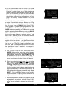
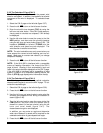
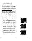
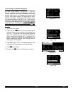
Figure 5-55
| FARM
|
|
|
|N 42^26.91'
|W 91^11.22'
|APT 1
5.4 USER-DEFINED WAYPOINTS
Up to 250 user-defined waypoints may be created.
These waypoints may be defined as a user-defined air-
port, VOR, NDB, or intersection. If the waypoint doesn’t
fit into one of these categories, it may be defined as a
supplemental (SUP) waypoint. An advantage of defin-
ing a user waypoint as a supplemental waypoint is that
its location may be entered as a radial and distance
from a VOR or from any other waypoint in the database.
5.4.1 Creating An Airport User Waypoint
A user defined airport waypoint must contain an
identifier, latitude, and longitude. In addition, any
combination of airport elevation, one runway length and
associated runway surface (hard or soft), and remarks
can also be stored. Communication frequencies cannot
be stored on the APT 4 page, airport services cannot be
stored on the APT 6 page, SIDs and STARs cannot be
stored on the APT 7 page, and approach procedures
cannot be stored on the APT 8 page. To create a user
waypoint as an airport:
1. Use the right outer knob to select the airport (APT)
type waypoints.
2. Rotate the right inner knob to select the APT 1 page.
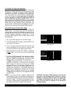
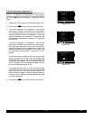
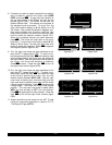
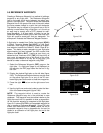
3. Press the right C to turn on the right cursor func-
tion. The cursor will appear over the first character
of the identifier (figure 5-53).
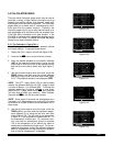
4. The next step is to select the identifier of the user
waypoint. The identifier can be one to four
characters in length. Use the right inner knob to
select the first character of the identifier.
5. Turn the right outer knob one step clockwise to
position the cursor over the second character and
then use the right inner knob to select the desired
character.
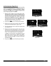
6. Use the right outer and inner knobs as described
above to finish selecting the identifier (figure 5-54).
7. If you wish to create a waypoint at your present posi-
tion (the position shown on the NAV 2 page), turn
the right outer knob clockwise to position the cursor
over PRES POS? and press E. The APT 1 page
will now be displayed with the latitude and longitude
of the waypoint at the bottom of the page (figure 5-
55).
Figure 5-53
| KATL
|HARTSFIELD-
|ATL
|CL C
|N 33^38.42'
|W 84^25.62'
|CRSR
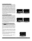
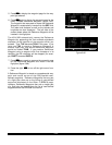
Figure 5-54
| FARM
|
|CREATE NEW
|WPT AT:
|USER POS?
|PRES POS?
|CRSR