


3-42
Rev 1
3.11 VIEWING THE WAYPOINT PAGES
You learned in section 3.7, “SELECTING WAYPOINTS”,
the different means of selecting the desired waypoint.
You will now see what information may be displayed for
each of the waypoint types (airport, VOR, NDB, intersec-
tion, and supplemental).
3.11.1 Airport Pages
There are eight airport pages (APT 1, APT 2, ..., APT 8)
for every airport in the published database. The database
primary area contains public use and military airports that
have a runway at least 1000 feet in length (see section
2.2, "Database Coverage Areas and Contents"). We will
use Orlando Executive airport to illustrate what is
contained on the airport pages.
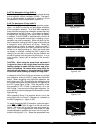
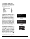
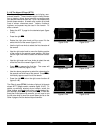
3.11.2 The Airport 1 Page (APT 1)
See figure 3-133.
• Airport identifier. An arrow precedes the identifier if it
is the active waypoint.
• Airport name.
• If the airport underlies the outer boundary of a Class B
or C airspace, CTA (Control Area - used outside
USA), or TMA (Terminal Area - used outside USA),
the letters CL B, CL C, CTA, or TMA, respectively,
will appear on the left side of this line. Note that there
is no altitude information applied to this criteria.
In addition, if the airport is a military airport the letters
MILTRYwill appear on the right side of this line. If the
airport is a private airport, the letters PRIVAT will
appear.
• The latitude and longitude of the airport reference
point (the “official” location of the airport).
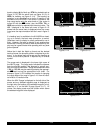
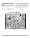
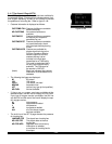
As shown in figure 3-134, the APT 1 page has a different
format when it is displayed as one of the nine nearest air-
ports (see section 3.7.3 “Nearest And Complete Waypoint
Scan List” and section 3.7.3.1 “Nearest Airports In An
Emergency”.
• To the right of the airport identifier are the letters “NR”
followed by a number designating the nearest airport
(NR 1), second nearest airport (NR 2), etc. to the air-
craft’s present position.
• The length, surface, and lighting of the longest run-
way.
• The bearing and distance to the airport.
|=KORL nr 1
|EXECUTIVE
|
| 5998' HRD
|L 132^t]
| 03.1nm
Figure 3-134
|=KORL
|EXECUTIVE
|
|CL B
|N 28^32.71'
|W 81^19.99'
Figure 3-133