Rev 1
B-1
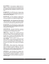
The following is a list of the messages that can appear
on the Message page. When the message prompt
appears, press MSG to view the message page. See
section 3.5 for an explanation of the Message page.
ACTV ANNUNCIATOR FAIL - This message appears
when there is a failure of the KLN 90B ACTV annuncia-
tor drive circuitry. To determine if the approach mode is
active you will need to look at the status line of the
KLN 90B because the annunciator will not be working if
this message has been given. Service the KLN 90B as
soon as possible.
ADJ NAV IND CRS TO 123° - (Adjust Navigation
Indicator Course to 123°) When this message appears,
the pilot should select the suggested course on the HSI
or CDI. When the KLN 90B is in the Leg mode, this
message occurs at the beginning of turn anticipation
(prior to reaching the active waypoint) if the upcoming
course change is greater than 5°. See section 4.2.2.
This message will also appear in installations where the
KLN 90B is interfaced with an HSI such that the
KLN 90B has the capability of reading the selected
course from the HSI. In the Leg mode it will appear
whenever the difference between the HSI’s selected
course and the KLN 90B’s desired track (DTK) is
greater than five degrees.
ADJ NAV IND CRS - (Adjust Navigation Indicator
Course) This message will appear in installations where
the KLN 90B is interfaced with EFIS or with a mechani-
cal HSI through the optional KA 90 adapter. This mes-
sage appears when the difference between the HSI’s
selected course and the KLN 90B’s selected course
(OBS) is greater than 0.5°. This usually happens only
when the external indicator is not slewed to a new value
defined by the KLN 90B. Check the interface between
the KLN 90B and the external indicator to determine the
problem.
AIRSPACE ALERT - This message appears when the
estimated time to enter a special use airspace is
approximately 10 minutes or when the distance from an
area of special use airspace is less than two nautical
miles. See section 3.10.
ALTITUDE FAIL - This message appears if the altitude
input to the KLN 90B fails. The altitude related features
of the KLN 90B will be disabled. There also may be
more RAIM related messages since altitude is not
available to help in the integrity calculations. Have the
installation checked as soon as practical to determine
the cause of the problem.
APT ELEVATION UNKNOWN - (Airport Elevation
Unknown) This message appears if the elevation of the
airport which would otherwise be used for the height
above airport alert is unknown.
ARINC 429 AIR DATA FAIL - This message appears if
the KLN 90B is interfaced with an air data system hav-
ing ARINC 429 outputs and the outputs are not being
received correctly by the KLN 90B.
ARINC 429 OUTPUT FAIL - This message appears
when the ARINC 429 output fails an internal test.
Anything depending on the KLN 90B’s ARINC 429 out-
put, such as the EHI 40/50 electronic HSI and some
navigation graphics displays, should not be used.
ARM ANNUNCIATOR FAIL - This message appears
when there is a failure of the KLN 90B ARM annunciator
drive circuitry. To determine if the approach mode is
armed you will need to look at the status line of the KLN
90B because the annunciator will not be working if this
message has been given. Service the KLN 90B as soon
as possible.
ARM GPS APPROACH - If the approach ARM mode
has been disarmed then the KLN 90B will remind you to
ARM the approach mode when the aircraft is 3 NM from
the Final Approach Fix. Arm the approach mode if it is
desired to use the KLN 90B for conducting an approach.
BAD SATELLITE GEOMETRY
AND RAIM NOT AVAILABLE - This message appears
only when the unit is in the approach active mode, RAIM
is not available and the satellite geometry has further
degraded to cause more uncertainty of the aircraft posi-
tion. This message may be followed by a NAV flag (in a
couple of minutes) if conditions continue to degrade.
BAD SATELLITE GEOMETRY
SEE EPE ON STA 2 PAGE - This message will occur
after receiving a notice that RAIM is not available. This
means that the geometry of the satellites is such that
the possible error in position is greater than allowed for
IFR use. Cross check the position of the aircraft with
other means of navigation every 15 minutes to verify
that the position is still accurate.
APPENDIX B - MESSAGE PAGE MESSAGES


