


5-22
Rev 1
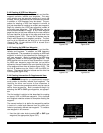
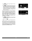
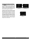
5. Press E to display the waypoint page for the way-
point just entered.
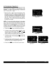
6. Press E again to display the waypoint page for the
newly created Reference Waypoint (figure 5-85).
The waypoint that was used to create the Reference
Waypoint is automatically inserted into the REF field.
The radial and distance as well as the latitude and
longitude are also displayed. The left side of the
screen shows where the Reference Waypoint will be
inserted in the flight plan.
The KLN 90B automatically names the Reference
Waypoint by appending the first available alphabetic
character to the identifier of the waypoint which you
entered. Thus, TXK becomes TXKA in this case. If you
later use TXK to create a Reference Waypoint in
another flight plan, this second Reference Waypoint
would be named TXKB. If you create a Reference
Waypoint using a waypoint with five characters in its
identifier, the fifth character will be dropped (for exam-
ple, DUSTT becomes DUSTA).
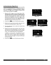
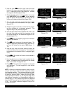
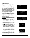
7. Press E once again to approve the waypoint page
for the Reference Waypoint and insert it into the
flight plan (figure 5-86).
8. Press the right C to turn off the right cursor func-
tion.
A Reference Waypoint is stored as a supplemental way-
point and counts as one of the 250 possible user-
defined waypoints. Reference Waypoints that are part
of a flight plan show up on the listing of user-defined
waypoints displayed on the Other 3 (OTH 3) page.
However, Reference Waypoints that are no longer part
of a flight plan are deleted from the list of user-defined
waypoints when the KLN 90B is turned off.
Figure 5-86
USE? INVRT?|
1:KDAL |
2:BUJ |ENTER REF
3:TXKA |WPT:
4:KLIT |
5: |
FPL 2 enr-leg CRSR
Figure 5-85
USE? INVRT?| TXKA
1:KDAL |REF: TXK
2:BUJ |RAD: 330.3^
3:TXKA |DIS: 32.8nm
4:KLIT |N 34^01.08'
5: |W 94^19.67'
CRSR enr-leg ent SUP