


3-32
Rev 1
3.9.2 The Super NAV 1 Page
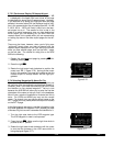
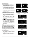
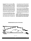
When the NAV 1 page is selected on both the left and
right sides at the same time, the Super NAV 1 page is
displayed (figure 3-102). The Super NAV 1 page contains
exactly the same information as the standard NAV 1 page
but spreads the data out across the entire screen making
it even easier to view. The word “FLAG” is displayed over
the CDI when the KLN 90B is not usable for navigation.
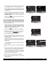
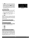
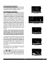
3.9.3 The Navigation 2 Page (NAV 2)
The NAV 2 page in figure 3-103 displays the aircraft’s
present position in two formats. The first format is in
terms of the distance and radial from a nearby VOR.
(Although terminal VORs are in the database, they are
not used on this page since many aeronautical charts do
not display a compass rose around them for orientation
purposes). The second format is in latitude and longitude.
NOTE: When flying non-precision approach procedures
that contain DME arcs, the VOR/DME station that defines
the arc is always displayed on the NAV 2 page even if the
reference is a terminal VOR/DME. This occurs when the
aircraft is within 30 NM of the arc.
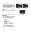
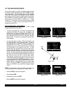
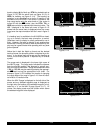
3.9.4 The Navigation 3 Page (NAV 3)
The NAV 3 page, such as shown in figure 3-104, displays
the following supplementary navigation information:
• Desired track (DTK) - The great circle course between
two waypoints. Any CDI or HSI driven by the KLN
90B, including the CDI displayed on the NAV 1 page,
is referenced to this DTK. You may wish to view the
navigation terminology diagram in Appendix A at this
time if you are unfamiliar with terms like desired track
and actual track.
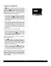
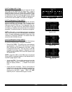
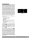
NOTE: If the KLN 90B is in the OBS mode, the selected
course (OBS) is displayed instead of the desired track on
the NAV 3 page (figure 3-105).
• Actual track(TK)- The aircraft’s present track over the
ground. Note: If there is insufficient velocity, the KLN
90B will display dashes (- - -) instead of the actual
track.
• Cross track error correction - This is a text means of
indicating how far and which direction to get back on
course. It is consistent with the vertical deviation bar
displayed on the NAV 1 page. “FLY L 2.7 NM”
means fly left 2.7 nautical miles to get on course.
$=KOSH
DIS 683nm ETE 3:34
GS 193kt BRG 303^
NAV 1 enr-leg NAV 1
Figure 3-102
PRESENT POS|
|
LGA 045^fr|
15.2nm|
N 41^00.03'|
W 73^41.62'|
NAV 2
Figure 3-103
$=OSH |
DTK 303^|
TK 302^|
FLY L 2.7nm|
MSA 3300ft|
ESA 5500ft|
NAV 3
Figure 3-104
=KOSH |
OBS 281^|
TK 302^|
FLY R 0.2nm|
MSA 3000ft|
ESA 3700ft|
NAV 3
Figure 3-105