


3-34
Rev 1
3.9.5 The Navigation 4 Page (NAV 4)
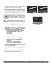
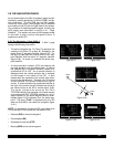
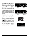
The NAV 4 page (figure 3-107) is used for altitude alerting
and for advisory vertical navigation (VNAV). The opera-
tion of altitude alerting is described in section 3.15 and
the operation of VNAV is described in section 5.2.
3.9.6 The Navigation 5 Page (NAV 5)
The NAV 5 page provides a navigation graphics presen-
tation. It is useful in providing you with proper orientation
of the navigation situation. In all KLN 90B installations
there are three common map orientation formats that may
be selected on the NAV 5 page: a True North up display,
a desired track up display, or an actual track up display.
In addition, if the KLN 90B is interfaced with a source of
heading in a compatible format then a heading up pre-
sentation may also be selected. When the North up dis-
play is selected, viewing the NAV 5 page is like looking at
a navigation chart with North at the top. When the
desired track up display is selected, viewing the NAV 5
page is like looking at a chart that is turned so that your
course line is always pointing up. When the actual track
up display is selected, viewing the NAV 5 page is like
looking at a chart that is turned so that the direction the
aircraft is tracking over the ground is pointing up. In a no
wind condition, actual track is identical to the aircraft’s
heading.
CAUTION: When using the actual track up format it
is typical for there to be a slight delay from the time a
heading change is made until the correct map orien-
tation is displayed. Be careful when using either the
desired track up display or the actual track up display
to not think that a heading up display is being used.
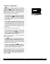
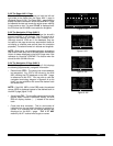
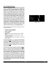
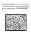
In chapter 4 of this Pilot’s Guide you will learn to use flight
plan operation where the NAV 5 page really becomes
useful. When navigating using flight plan operation, the
active flight plan (FPL 0) waypoints are displayed using
the number associated with the waypoint as it appears on
the FPL 0 page (figure 3-108). Thus, the position of the
third waypoint in FPL 0, MXE, is indicated by a 3 on the
NAV 5 page. Lines connect the flight plan waypoints. An
arrow points to the active waypoint and shows the current
flight plan leg.
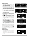
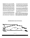
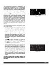
When operating Direct To a waypoint which is not in the
active flight plan the Direct To waypoint is indicated on
the NAV 5 page by an * (figure 3-109).
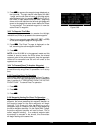
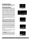
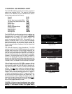
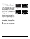
To select the desired NAV 5 orientation, press the appro-
priate C(left Cif NAV 5 page is on left side and vice
versa). The cursor will be over the map range scale (fig-
ure 3-110). Turn the appropriate outer knob one step
counterclockwise to position the cursor over the map ori-
entation field (figure 3-111). Rotate the appropriate inner
VNV 6200ft|
|
IND 6300ft|
SEL: 3500ft|
KOSH :-03nm|
ANGLE:-1.8^|
NAV 4
Figure 3-107
1:KMDT |
; 2:LRP |
< 3:MXE |
4:KPHL |
5: |
|123^ 40
FPL 0 enr-leg NAV 5
4
3
2
Figure 3-108
|
|
|
|
|
NŸ 40|
NAV 5
*
1
2
3
4
i
j
Figure 3-109
1
2
3
4
i
j
|
|
|
|
|
NŸ 40|
CRSR
Figure 3-110
1
2
3
4
i
j
|
|
|
|
|
NŸ 40|
CRSR
Figure 3-111