


4-2
Rev 1
4.1.1 Creating A Flight Plan
A flight plan for a flight from Lakefront airport in New
Orleans, LA. to St. Petersburg/Clearwater, FL.
International airport will be used as an example of how to
create a flight plan. The waypoints making up the flight
plan are: KNEW(Lakefront airport), GPT(Gulfport VOR),
SJI(Semmes VOR), CEW(Crestview VOR),MAI
(Marianna VOR), TLH(Tallahassee VOR), CTY(Cross
City VOR), and KPIE(St. Petersburg/Clearwater
International airport. To create the flight plan:
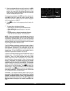
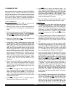
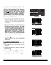
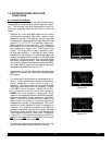
1.Rotate the left outer knob to select the flight plan
(FPL) type pages (figure 4-1).
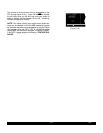
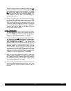
2.Turn the left inner knob to select a flight plan page
(preferably other than FPL 0) which does not contain
a flight plan (figure 4-2). If all of the flight plan pages
contain flight plans, refer to section 4.1.5, “Deleting
Flight Plans.”
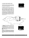
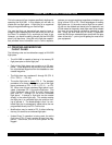
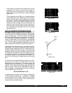
3.Press the left
Cto turn on the cursor function for the
left page (figure 4-3).
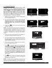
NOTE: The KLN 90B flight plan operation is designed so
that the first waypoint in the flight plan should always be
the departure point. Remember to enter the “K”, “P”, or
“C” prefix for certain airports in the United States, Alaska,
or Canada. See section 2.3, “USE OF ICAO IDENTI-
FIERS.”
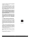
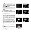
4.Use the left inner knob to select the first character of
the departure waypoint identifier (figure 4-4).
5.Turn the left outer knob one step clockwise to move
the flashing portion of the cursor over the second
character position, and then use the left inner knob to
select the desired character.
6.Use the above procedure to select the entire identifier
for the first waypoint (figure 4-5).
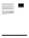
7.Press E. A waypoint page for the identifier just
entered will be displayed on the right side (figure 4-6).
If a mistake was made and the wrong waypoint identi-
fier was entered, press @and begin again. If a mis-
take was not made but the waypoint identifier just
entered isn’t in the database, a page allowing creation
of a user defined waypoint will appear on the right
side. Refer to section 5.4, “USER-DEFINED WAY-
POINTS”, for instruction on how to define a user cre-
ated waypoint.
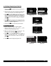
8.Press Eagain to approve the waypoint page being
displayed. The cursor will move to the second
waypoint position (figure 4-7).
NOTE: A small number of waypoints are stored in the
database as “fly-over” waypoints. These waypoints are
associated with SID/STAR procedures. “Fly-over” means
USE? INVRT?|
1:KMKC |
2:BUM |
3:OSW |
4:TUL |
6:KRVS |
FPL 8
Figure 4-1
LOAD FPL 0?|
1: |
|
|
|
|
FPL 4
Figure 4-2
LOAD FPL 0?|
1: |
|
|
|
|
CRSR
Figure 4-3
LOAD INVRT?|
1:K |
2: |
|
|
|
CRSR
Figure 4-4
LOAD INVRT?|
1:KNEW |
2: |
|
|
|
CRSR
Figure 4-5
USE? INVRT?| KNEW
1:KNEW |LAKEFRONT
2: |
| CL C
|N 30^02.53'
|W 90^01.69'
CRSR|enr-leg ent|APT 1
Figure 4-6
USE? INVRT?|
1:KNEW |
2: |
|
|
|
CRSR
Figure 4-7