


3-45
Rev 1
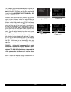
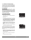
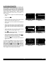
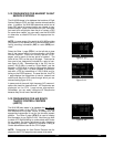
3.11.5 The Airport 4 Page (APT 4)
See figure 3-138
The APT 4 page is used to display communication fre-
quencies for the selected airport.
• Airport identifier. An arrow precedes the identifier if it
is the active waypoint.
• Frequencies for:
ATIS - automatic terminal information service
PTAX- pre-taxi clearance
CLR - clearance delivery
GRND- ground control
RAMP- ramp/taxi control
TWR - tower
UNIC - unicom
MCOM- multicom
CTAF- common traffic advisory frequency
RDO - radio
MF - mandatory frequency
ATF - aerodrome traffic frequency
AFIS - aerodrome flight information service
CL B - Class B (VFR frequency)
CL C - Class C (VFR frequency)
TRSA- terminal radar service area (VFR
frequency)
CTA - control area (VFR frequency used out
side USA)
TMA - terminal area (VFR frequency used
outside USA)
APR - approach control
DEP - departure control
CTR - center (when center is used for
approach/departure control)
ARVL- arrival
RDR - radar only frequency
DIR - director (approach control/radar)
ASOS- automated surface observation system
AWOS- automatic weather observing station
AAS - aeronautical advisory service
PCL - pilot controlled lighting
In addition to the standard VHF frequencies shown in fig-
ure 3-138, HF frequencies are shown at airports that uti-
lize “high frequency” communications that fall in the 2000
kHz to 30,000 kHz frequency band. These are typically
used in remote areas of the world. One way to tell HF
frequencies is that they do not contain a decimal point. A
display of 6547would indicate a frequency of 6,547 kHz.
Airports which have numerous communication frequen-
cies will have multiple Airport 4 pages indicated by
APT+4.
Part-time operation, such as for a control tower, is indi-
cated with an*to the left of a frequency.
|=KORL
|ATIS*127.25
|CLR *118.05
|GRND*121.40
|TWR *118.70
|CTAF*118.70
APT[4
Figure 3-138