


5-21
Rev 1
5.5 REFERENCE WAYPOINTS
Creating a Reference Waypoint is a method of adding a
waypoint to any flight plan. The Reference Waypoint
lies on the great circle route between two other way-
points in the flight plan. The point where the Reference
Waypoint lies on the great circle route is the point where
the route passes closest to a point that you designate.
The feature may be utilized on the ground as an aid in
defining a route before filing a flight plan, or in the air as
an easy way to comply with an ATC request for addi-
tional waypoints. It is also useful, at times, to use the
Reference Waypoint feature just to see how close your
flight will come to some point that you designate. An
example will illustrate the Reference Waypoint feature.
A flight plan is created from Dallas Love airport (KDAL)
in Dallas, Texas to Adams Field (KLIT) in Little Rock,
Arkansas. Blue Ridge VOR (BUJ) is added as a depar-
ture waypoint outside the Dallas-Ft. Worth Class B air-
space. You desire to add a waypoint to your flight plan
approximately half way between the 223 nautical mile
distance from BUJ to KLIT. Looking at your chart, you
determine that Texarkana VOR (TXK) is in the vicinity of
your route, but appears to be a little South of the route.
Since you don’t want to fly any out of your way, you
decide to create a reference waypoint using TXK.
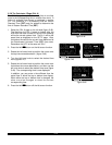
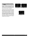
1. Select the Reference Waypoint (REF) page on the
right side. If a flight plan page is not displayed on
the left side, the REF page looks like the one in fig-
ure 5-82.
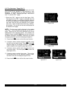
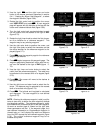
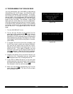
2. Display the desired flight plan on the left side (figure
5-83). The Reference Waypoint feature may be used
on the active flight plan or on any of the 25 num-
bered flight plans that contain at least two waypoints.
3. Press the right C to turn on the right cursor func-
tion.
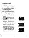
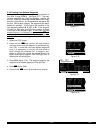
4. Use the right inner and outer knobs to enter the iden-
tifier of the desired waypoint (figure 5-84).
NOTE: The waypoint which is used to create the
Reference Waypoint may be in the published or user
database. This waypoint must be located relative to the
flight plan such that it is possible to draw a perpendicu-
lar line from this waypoint to a segment of the flight plan.
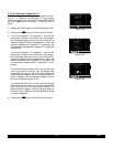
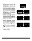
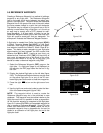
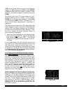
figure 5-81 shows that TXK is an acceptable waypoint to
use in creating a Reference Waypoint. figure 5-81 also
shows that Greenwood VOR (GRW) would not be an
acceptable waypoint since a perpendicular line can be
drawn to an extension of the flight plan, but not to the
flight plan itself.
KDAL
BUJ
TXKA
TXK
KLIT
GRW
330°
32.9NM
6-81
N
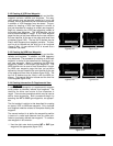
Figure 5-82
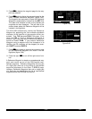
PRESENT POS|
|DISPLAY
DBQ 274^fr|DESIRED
21.3nm|FPL ON
N 42^26.91'|LEFT PAGE
W 91^11.17'|
NAV 2 enr-leg REF
Figure 5-83
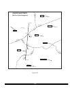
USE? INVRT?|
1:KDAL |
2:BUJ |ENTER REF
3:KLIT |WPT:
4: |
|
FPL 2 enr-leg REF
Figure 5-84
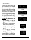
USE? INVRT?|
1:KDAL |
2:BUJ |ENTER REF
3:KLIT |WPT: TXK
4: |
|
FPL 2 enr-leg ent CRSR
Figure 5-81