


5-9
Rev 1
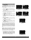
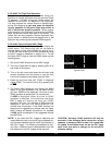
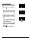
5.2.2 VNAV For Flight Plan Operation
Using the vertical navigation function when flying via a
flight plan is virtually the same as for the previous Direct
To example. The NAV 4 page will initially contain the
identifier for the active “to” waypoint in the flight plan.
You may program the vertical ascent or descent refer-
encing this waypoint or you may enter the identifier
for any waypoint in the active flight plan which is
still in front of the aircraft’s position. When another
valid waypoint in the flight plan is entered on the NAV 4
page, the aircraft’s lateral flight path is not altered. This
means that you may program a vertical flight path hav-
ing an ascent or descent point that begins prior to the
flight plan leg containing the selected VNAV waypoint.
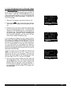
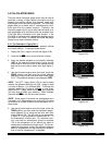
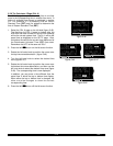
5.2.3 VNAV From the Super NAV 5 Page
The Super NAV 5 page can be configured to display the
VNAV status. This means that you will not have to
change pages to see what altitude you should be at.
You will still need to set up the VNAV problem by using
the NAV 4 page as described in section 5.2.1. To use
the Super NAV 5 page to view the VNAV status use the
following steps.
1.Set up the VNAV situation from the NAV 4 page.
2.Turn to the Super NAV 5 page by selecting NAV 5 on
both sides of the display.
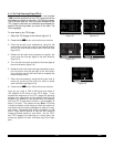
3.Turn on the left cursor and rotate the left outer knob
counter-clockwise until the cursor is over the third
line from the bottom of the display (figure 5-28a).
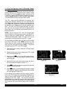
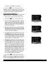
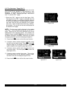
4.Rotate the left inner knob until “VNAV” is displayed
(figure 5-28b). Turn the left cursor off by pressing the
left C.
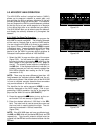
5.The Super NAV5 page will now display the VNAV
status. If the VNAV problem has not been defined
yet, then V OFFwill be displayed. If the time to start
VNAV operation is greater than 10 minutes then
V ARMis displayed. When the time to VNAV
operation is less than 10 minutes then the Super
NAV 5 page will display the time until VNAV
operation will start. For example, V 4:53would be
displayed if the time until VNAV operation is 4
minutes and 53 seconds. If the VNAV function has
started and is suggesting an altitude then the Super
NAV 5 display will display this altitude. For example
V 4300would be displayed if the suggested altitude
was 4300 feet.
NOTE: If you used the CAL 4 page to determine the
ascent/descent angle, the aircraft’s groundspeed dur-
ing the ascent/descent should match that entered on
the CAL 4 page. If a different groundspeed is actu-
ally flown, a different rate of ascent/descent from the
one entered on the CAL 4 page will be required.
Figure 5-28a
25.5 oq
KPIE |
xy-«} |
201 uv
ETE |
ûü172^|
†ü173^|30
KPIE
24.6 oq
KPIE |
xy-«} |
201 uv
VNAV |
ûü172^|
†ü173^|30
KPIE
Figure 5-28b
CAUTION: Advisory VNAV operation will only be
accurate if the altimeter baro correction is kept
updated. If advisory VNAV is used, it is a good idea
to update the altimeter baro set on the ALT page
each time you make a change to the aircraft’s
altimeter setting.