


Chapter 1: System overview and features 7
Comprehensive Weather/ Oceanographic
reporting
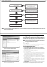
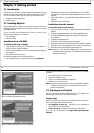
RayTech offers you the capability to download and display the latest
weather and ocean conditions, and then superimpose this information
upon your charts in several layers. Weather and oceanographic charts (in
GRIB format) can be downloaded directly from the Internet or requested
via e-mail. These files can be animated to show predicted weather condi-
tions over a specified period of time. Typical weather files contain
information covering a period of several days, giving you a comprehensive
presentation of atmospheric and marine conditions.
These features require online registration at www.raymarine.com.
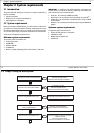
Advanced graphical user interface
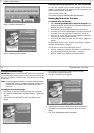
RayTech is operated via an easy-to-use Graphical User Interface (GUI)
complete with many customizable toolbars, softkeys and ‘floating’ data
boxes. Using an intuitive menu hierarchy, you can display only those tools
that you commonly use, or customize screens to show you only pertinent
information, with just a few mouse clicks. RayTech’s flexible GUI enables
you to quickly and easily tailor its powerful resources to suit your needs.
Navionics Platinum chart card
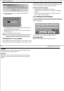
Compatibility with Navionics Platinum chart card provides you with
enhanced 2D cartography features, and introduces an easy to use 3D chart
format that provides you with a graphical view of land and sea contours
around your boat. Much of the information available on a conventional
chart can be shown in three dimensions, giving you an accurate easy-to-
view image of the area around.
To read Navionics Platinum Chart cards you will need to install a Navionics
CF chart card reader - Part No. E86026, or have RayTech connected via
SeaTalk
hs
to an E-Series display.
Sailboat racing
The sail racer features are targeted towards the professional sailboat racer,
and include
• DataTrak.
•Polars.
• Route Optimization.
• Advanced weather routing.
• Pre-start display.
• Navigation numbers.
• Specialized racing toolbar.
Fishing (US market only)
The fishing features are targeted towards the serious fisherman Raymarine
offers subscription services to support the following fishing features:
• Ocean plankton - using data from the Orb View 2 satellite.
• Sea surface temperature (SST) - using data from U.S. Government
weather satellites.
These features require online registration at www.raymarine.com.
8 RayTech RNS V6.0 - Users Guide