


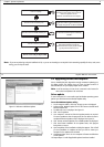

Contents 1
Contents
Important information ................................................................1
Safety notices........................................................................................1
WARNING .............................................................................................1
WARNING .............................................................................................1
CAUTION...............................................................................................1
Intended use .........................................................................................1
Disclaimers............................................................................................1
The limits of electronic navigation ........................................................2
About this manual.................................................................................2
Conventions used..................................................................................3
Product use ...........................................................................................3
System integration ................................................................................3
Technical accuracy ................................................................................3
Copyright ..............................................................................................3
System overview and features...................................................5
Introduction.......................................................................................... 5
What do I get in the box?..................................................................... 5
CAUTION...............................................................................................6
System overview .................................................................................. 6
System features.................................................................................... 6
Easy marine navigation ..................................................................... 6
Chart formats .................................................................................... 6
Comprehensive Weather/ Oceanographic reporting .......................... 7
Advanced graphical user interface..................................................... 7
Navionics Platinum chart card........................................................... 7
Sailboat racing................................................................................... 7
Fishing (US market only).................................................................... 7
System requirements ...................................................................9
Introduction.......................................................................................... 9
System requirements............................................................................ 9
Minimum system requirements.......................................................... 9
Optimum system requirements.......................................................... 9
Is my PC ready to use RayTech?......................................................... 10
Upgrading drivers and adapters ......................................................... 12
Driver update................................................................................... 12
DirectX............................................................................................. 13
Useful websites................................................................................ 14
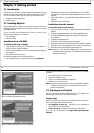
Getting started............................................................................15
Introduction........................................................................................ 15
Installing RayTech .............................................................................. 15
Installation from a CD-ROM............................................................. 15
Installation from the internet........................................................... 15
Starting to use RayTech...................................................................... 16
License keys..................................................................................... 16
Running RayTech for the first time................................................... 17
Using RayTech on a new computer.................................................. 19
Continuing To Use RayTech................................................................ 19
Operating modes............................................................................. 19
Simulator......................................................................................... 21
Setting up RayTech ............................................................................ 21
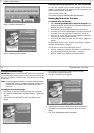
Installing instruments to RayTech....................................................... 22
RayTech Tools.................................................................................. 22
File/Setup/Instruments feature......................................................... 22
Installing charts.................................................................................. 26
C-MapNT+/PC charts from CD-ROM................................................ 26
Maptech cartography....................................................................... 26
2 RayTech RNS V6.0 - Users Handbook
Navionics cartography...................................................................... 26
RayTech chart installer..................................................................... 27
The User Interface and controls ...............................................29
Introduction........................................................................................ 29
The screen........................................................................................... 29
Interface controls................................................................................ 29
Drop down menus............................................................................ 30
Toolbars ........................................................................................... 30
Softkeys............................................................................................ 30
Right mouse menus.......................................................................... 30
Pathfinder panel............................................................................... 31
Displaying information........................................................................ 31
Selection dialog box......................................................................... 31
Action box........................................................................................ 32
Data box........................................................................................... 32
Alert and information dialog box..................................................... 32
Application information box............................................................. 33
Changing what you see on the screen................................................ 33
Moving around a split page ............................................................. 34
Using charts..................................................................................37
Introduction........................................................................................ 37
Use your charts safely ...................................................................... 37
The chart screen.................................................................................. 37
Opening a chart.................................................................................. 37
Moving around the chart.................................................................... 38
Chart panning .................................................................................. 38
Zooming........................................................................................... 38
Finding your boat on the chart......................................................... 38
Choosing a chart type......................................................................... 38
Chart layers...................................................................................... 39
Chart order...................................................................................... 39
Chart quilting .................................................................................. 40
Using Platinum cartography .....................................................43
Introduction ....................................................................................... 43
2D cartography................................................................................ 43
3D bathymetric charts..................................................................... 43
New 2D chart features....................................................................... 44
Aerial photo overlay........................................................................ 44
Panoramic photos ........................................................................... 44
Pilot book........................................................................................ 45
2D chart enhancements..................................................................... 46
Business services information.......................................................... 46
Find nearest..................................................................................... 46
Search port by name ....................................................................... 47
Wrecks data .................................................................................... 47
Coastal roads .................................................................................. 48
US inland waterways....................................................................... 48
3D bathymetric chart application....................................................... 49
The application................................................................................ 50
The controls..................................................................................... 50
The operating modes....................................................................... 50
Making the view clearer.................................................................. 52
Using 2D and 3D charts together .................................................... 53
Navigating with 3D Charts.............................................................. 53
Working with waypoints ...........................................................55
Introduction ....................................................................................... 55
What is a waypoint?.......................................................................... 55
Placing a waypoint............................................................................. 55
...at the cursor’s current position..................................................... 55
... at the boat’s current position...................................................... 55