


151
Appendix A: Charts
A.1 Introduction
This appendix gives additional information on charts used in RayTech and
includes:
• Chart formats.
• Chart types.
• Displaying chart object and source information.
•Waypoints.
• Routes.
•Tracks.
A.2 Safety
CAUTION: The equipment should not be used as a substitute for
good navigational practice nor for official government paper
charts.
RayTech makes it very easy to place a waypoint and travel towards it.
However, you should always check first that the route is safe. If you are
using RayTech in combination with an autopilot, the autopilot will prompt
for confirmation before it steers the boat towards the waypoint.
If you have entered a route using a small scale chart, zoom in to a larger
scale to check for hazards, such as small shoals, that may not be shown on
the smaller scale charts.
Note:
Until you are familiar with interpreting the chart display, you should
take every opportunity to compare the displayed objects with visual targets,
such as buoys and coastal structures. You should practise harbor and coastal
navigation during daylight and in clear weather conditions.
A.3 Chart formats
RayTech uses the latest digitized versions of the following charts:
• Navionics HotMaps, HotMaps Premium, Silver, Gold and Platinum
charts.
• C-Map NT,NT Plus,.
• C-Map NT/PC Selector charts.
•Maptech NOAA/BSB.
• Maptech PCX.
• Maptech Photo Regions and Topographical Charts.
• SoftCharts International Nautical Charts and PhotoNavigator.
• NDI/HS Charts.
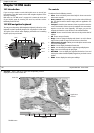
A.4 Chart types
Charts fall into three basic types:
Vector
A paper chart that has been digitized into a format consisting of line
segments. Vector charts can be easier to read than a rasterized chart, but
may not include the level of detail found in Raster charts. C-Map charts are
examples of a vector chart.
Raster
A paper chart that has been scanned into a high resolution image. A raster
chart has the advantage of being virtually identical to the original paper
chart from which it was scanned. Maptech NOAA/BSB and PCX charts are
examples of raster charts.
152 RayTech RNS V6.0 - Users Guide
Aerial imagery
A high resolution, geo-referenced rasterized photograph taken from aerial
or satellite sources. You can overlay your boat’s position on such an image,
and get a visual estimation of your position with reference to actual,
photography based landmarks. Navionics aerial photographs and Maptech
Photo Region charts are examples of this type of chart.
A.5 Displaying chart object and source
information
Vector charts used with RayTech include a number of displayed objects for
which information is available, such as lights and buoys. They also contain
additional source data for structures, lines, open sea areas etc. You can use
the right mouse menu to identify an object or chart position and you can
obtain detailed information for the selected item.
Waypoints
A Waypoint is a position entered on a chart as a reference, or as a place to
go. All waypoints placed on the chart plotter are stored in a waypoint data-
base list which includes additional information about each individual
waypoint.
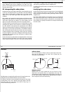
Routes
A route is made up of a series of waypoints. To make a route a series of
waypoints is placed on the chart, or can be selected from the Waypoint
List.
When a route is created it becomes the current route and is displayed on-
screen. The current route is maintained even when the system is powered-
off. Only one route can be current and is displayed (if it is in the field-of-
view) as solid lines connecting waypoints. If the route is being followed,
the current leg is shown as a dotted line and the previous legs are removed
from the screen (although the waypoints remain displayed).
Tracks
The track function is used to mark on-screen the trail that the vessel has
followed, as if it had left a visible wake.
While the track is switched on it is recorded in the system memory. The
interval at which track points are made and a line is drawn on-screen
between each point. The current track remains on screen, even following a
power off/on, until you clear the track.