


15-5190-01004-03 Rev. B
Garmin GTN 625/635/650 Pilot’s Guide
Foreword
Getting
Started
Xpdr Ctrl
Com/Nav
FPL
Direct-To
Proc
Wpt Info
Map
Traffic
Terrain
Weather
Nearest
Music
Utilities
System
Messages
Symbols
Appendix
Index
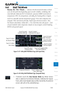
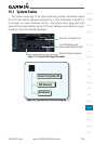
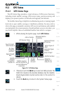
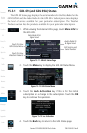
4. Touch the Back key to return to the System Status page.
NOTE: The data contained in the terrain and obstacle databases comes from
government agencies. Garmin accurately processes and cross-validates the
data, but cannot guarantee the accuracy and completeness of the data.
The following databases are stored on Supplemental Data Cards provided by
Garmin:
•Terrain–Theterraindatabase contains terrain mapping data. It is updated
periodically and has no expiration date.
•Obstacles–Theobstructionsdatabasecontainsdataforobstacles,suchas
towers, that pose a potential hazard to aircraft. Obstacles 200 feet and higher
are included in the obstacle database. It is very important to note that not
all obstacles are necessarily charted and therefore may not be contained in
the obstacle database. This database is updated on a 56-day cycle. Obstacles
will still be shown after the database has expired.
•SafeTaxi – The SafeTaxi database contains detailed airport diagrams for
selected airports. These diagrams aid in following ground control instructions
by accurately displaying the aircraft position on the map in relation to
taxiways, ramps, runways, terminals, and services. This database is updated
on a 56-day cycle. SafeTaxi will still be shown after it has expired.
•Basemap- TheBasemap database contains land and water data, such as
roads, boundaries, rivers, and lakes.
•Aviation–TheNavigationdatabaseisupdatedona28daycycle.Navigation
database updates are provided by Garmin and may be downloaded from the
Garmin web site “fly.garmin.com” onto a Garmin provided Supplemental
Datacard. Contact Garmin at fly.garmin.com for navigation database updates
and update kits.