


11-23190-01004-03 Rev. B
Garmin GTN 625/635/650 Pilot’s Guide
Foreword
Getting
Started
Xpdr Ctrl
Com/Nav
FPL
Direct-To
Proc
Wpt Info
Map
Traffic
Terrain
Weather
Nearest
Music
Utilities
System
Messages
Symbols
Appendix
Index
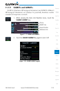
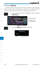
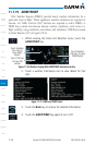
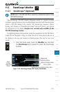
11.1.16 Winds Aloft
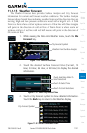
Winds Aloft data shows the forecast wind speed and direction at the surface
and at selected altitudes. Altitudes can be selected in 3000 foot increments from
the surface up to 45,000 feet.
1. While viewing the Data Link Weather menu, touch the Winds
Aloft key.
Wind Symbols
Selected Wind
Altitude
Touch To Select
Wind Altitude
Figure 11-34 Winds Aloft
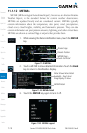
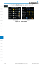
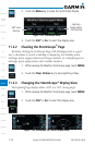
2. Touch the WX Aloft ALT – or + keys to increase or
decrease the reporting altitude of the winds aloft in 3,000
foot increments. The selected altitude is shown in a window
about the altitude keys.
3. Touch the Winds Aloft key again to turn it off.
Figure 11-35 Winds Aloft Legend