


7-13190-01004-03 Rev. B
Garmin GTN 625/635/650 Pilot’s Guide
Foreword
Getting
Started
Xpdr Ctrl
Com/Nav
FPL
Direct-To
Proc
Wpt Info
Map
Traffic
Terrain
Weather
Nearest
Music
Utilities
System
Messages
Symbols
Appendix
Index
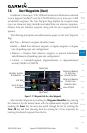
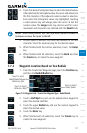
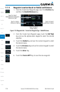
7.6 User Waypoints (User)
In addition to the airport, VOR, NDB and intersection information contained
in your Jeppesen NavData
®
card, the GTN 6XX allows you to store up to 1,000
user-defined waypoints. The User Waypoint Page displays the waypoint name
(up to six characters long), identifier and radial from two reference waypoints,
distance from one reference waypoint, along with the user waypoint’s lat/lon
position.
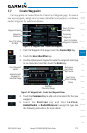
The following descriptions and abbreviations appear on the User Waypoint
Page:
•RefWpt—Referencewaypointidentier(name)
•Radial—Radialfromreferencewaypoint,indegreesmagneticordegrees
true (depending upon unit configuration)
• Distance — Distance from reference waypoint, in nautical miles/statute
miles/kilometers (depending upon unit configuration)
• Lat/Lon — Latitude/Longitude (degrees/minutes or degrees/minutes/
seconds), MGRS or UTM/UPS
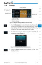
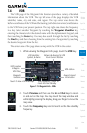
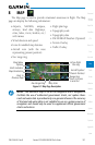
Distance & Bearing
To Wpt From
Current Position
Identifier, Symbol,
& References
Delete Wpt
Wpts Used
View All Wpts
Edit Wpt
Distance & Bearing
To Wpt From
Reference Wpt
Touch To View
Area Map
Figure 7-17 Waypoint Info for a User Waypoint
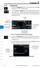
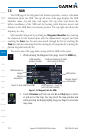
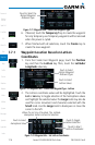
Select another Waypoint by touching the Waypoint Identifier key, entering
the characters for the desired name with the alphanumeric keypad, and then
touching the Enter key. You may also search through the list by touching the
View All key and then choosing from the existing list of User waypoints by
touching the desired waypoint from the list.