


11-10
Garmin GTN 625/635/650 Pilot’s Guide
190-01004-03 Rev. B
Foreword
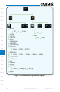
Getting
Started
Xpdr Ctrl
Com/Nav
FPL
Direct-To
Proc
Wpt Info
Map
Traffic
Terrain
Weather
Nearest
Music
Utilities
System
Messages
Symbols
Appendix
Index
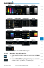
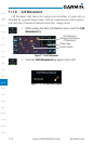
11.1.5.2 NEXRAD Limitations
NEXRAD radar images may have certain limitations:
•NEXRAD base reectivity does not provide sufficient information to
determine cloud layers or precipitation characteristics. For example, it is
not possible to distinguish between wet snow, wet hail, and rain.
•NEXRADbasereectivityissampledattheminimumantennaelevation
angle. An individual NEXRAD site cannot depict high altitude storms at
close ranges. It has no information about storms directly over the site.
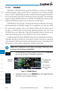
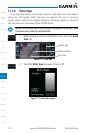
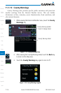
•Each square block on the display represents an area of four square
kilometers (2.15 NM). The intensity level reflected by each square
represents the highest level of NEXRAD data sampled within the area.
Block Area Is 4 km
2
(2.15 NM
2
)
Block Area Is 4 km
2
(2.15 NM
2
)
Figure 11-9 NEXRAD Data Blocks
The following may cause abnormalities in displayed NEXRAD radar images:
•Groundclutter
•Strobesandspuriousradardata
•Sunstrobes(whentheradarantennapointsdirectlyatthesun)
•Interferencefrombuildingsormountains,whichmaycauseshadows
•Metallicdustfrommilitaryaircraft,whichcancausealterationsinradar
scans