


12-10
Garmin GTN 625/635/650 Pilot’s Guide
190-01004-03 Rev. B
Foreword
Getting
Started
Xpdr Ctrl
Com/Nav
FPL
Direct-To
Proc
Wpt Info
Map
Traffic
Terrain
Weather
Nearest
Music
Utilities
System
Messages
Symbols
Appendix
Index
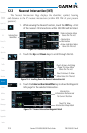
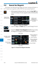
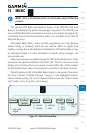
Selected
Airspace Sector
Current Position
Active Flight
Plan Leg
Airspace
Boundary
Airspace
Sector
Name
Map Pointer
Map Pointer
Location Relative
To Present Position
Figure 12-15 Airspace Sectors
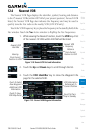
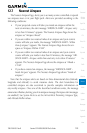
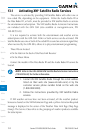
1. While viewing the Nearest function, touch the Airspace key.
A list of the nearest 25 Airspaces within 200 NM along the
aircraft flight path will be listed, depending on the airspace
types and values set by the user.
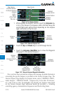
Airspace
Proximity
Information
Airspace
Name
Figure 12-16 Nearest Airspace List
2. Touch the Up and Down keys to scroll through the list.
3. Touch the Airspace Identifier key to show the Waypoint
Info page for the selected Airspace.
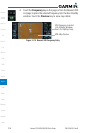
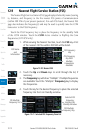
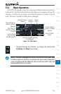
Touch To
View Airspace
Frequency List
Airspace
Name
Airspace
Information
Airspace Contact
Name
Touch To
View Airspace
Vicinity Map
Figure 12-17 Nearest Airspace Waypoint Information
Once you have been provided an airspace alert message, detailed information
concerning the specific airspace is provided on the Nearest Airspace Page. The
Nearest Airspace Page displays the airspace name, status (“AIRSPACE ALERT -
inside Airspace”, “AIRSPACE ALERT - Airspace entry in less than 10 minutes”,
etc.), and a time to entry (if applicable). By selecting any airspace name listed
on the Nearest Airspace Page, additional details are provided — including
controlling agency, communication frequencies and floor/ceiling limits.