


11-29190-01004-03 Rev. B
Garmin GTN 625/635/650 Pilot’s Guide
Foreword
Getting
Started
Xpdr Ctrl
Com/Nav
FPL
Direct-To
Proc
Wpt Info
Map
Traffic
Terrain
Weather
Nearest
Music
Utilities
System
Messages
Symbols
Appendix
Index
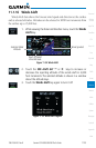
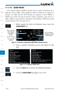
NOTE: Cell mode uses a clustering program to identify clusters of electrical
activity that indicate cells. Cell mode is most useful during periods of heavy
storm activity. Displaying cell data during these periods frees the user
from sifting through a screen full of discharge points and helps to better
determine where the storm cells are located.
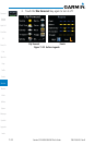
11.2.4 Changing the StormScope
®
Data Display
Range
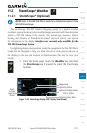
StormScope data can be displayed on the Map page 2000 NM zoom scale,
but the data only goes out as far as the StormScope can report (200 NM). The
500 NM zoom scale will display all lightning data. Scales greater than 500 NM
do not display any additional StormScope data.
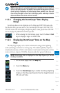
1. While viewing the StormScope page, touch the In and Out
keys to display a larger or smaller area.
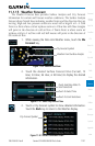
11.2.5 Displaying StormScope
®
Data on the Map
Page
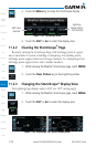
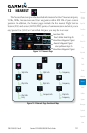
The Map Page displays cell or strike information using yellow lightning
strike symbology overlaid on a moving map. This added capability improves
situational awareness, which in turn makes it much easier for the pilot to relate
storm activity to airports, NAVAIDs, obstacles and other ground references.
NOTE: StormScope data is displayed on the Map Page only if aircraft
heading is available.
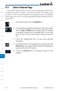
1. On the Home page, touch the Map key.
2. Touch the Menu key.
3. Touch the StormScope key to enable StormScope lightning
display on the Map page. Repeated touches toggle between
Off, Cell, and Strike.