


14-23190-01004-03 Rev. B
Garmin GTN 625/635/650 Pilot’s Guide
Foreword
Getting
Started
Xpdr Ctrl
Com/Nav
FPL
Direct-To
Proc
Wpt Info
Map
Traffic
Terrain
Weather
Nearest
Music
Utilities
System
Messages
Symbols
Appendix
Index
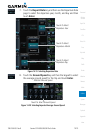
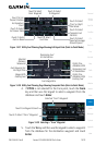
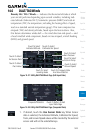
14.6 DALT/TAS/Winds
Density Alt / TAS / Winds — indicates the theoretical altitude at which
your aircraft performs depending upon several variables, including indi-
cated altitude (Indicated ALT), barometric pressure (BARO) and total air
temperature (TAT; the temperature, including the heating effect of speed,
read on a standard outside temperature gauge). This item computes true
airspeed (TAS) and density altitude, based upon the factors above. Also,
this feature determines winds aloft — the wind direction and speed — and
a head wind/tail wind component, based on true airspeed, aircraft heading
(HDG) and ground speed.
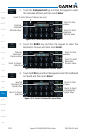
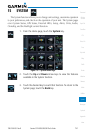
Touch To Select
Ground Speed
Touch To Select
Indicated Altitude
Touch To Select
Ext Sensor Data
Touch To Select
Baro Pressure
Touch To Select
Calibrated Air Speed
Touch To Select
Total Air Temp
Touch To Select
Track Value
Touch To Select
Heading Value
Touch To Compute Data
And View Statistics
Figure 14-37 Utility DALT/TAS/Winds Page (Edit Input Data)
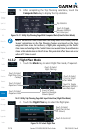
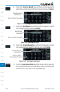
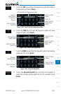
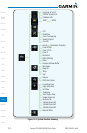
Touch To Return To Edit
Input Data Page
Computed Statistics
Figure 14-38 Utility DALT/TAS/Winds Page (Computed Data)
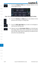
1. If desired, touch the Use Sensor Data key. When Sensor
data is selected, the Indicated Altitude, Calibrated Air Speed,
Track, and Ground Speed values will be inserted by the external
sensor and will not be selectable keys.