


8-20
Garmin GTN 625/635/650 Pilot’s Guide
190-01004-03 Rev. B
Foreword
Getting
Started
Xpdr Ctrl
Com/Nav
FPL
Direct-To
Proc
Wpt Info
Map
Traffic
Terrain
Weather
Nearest
Music
Utilities
System
Messages
Symbols
Appendix
Index
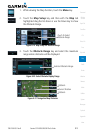
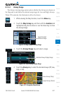
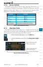
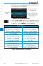
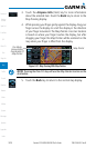
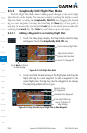
3. Touch the corner data field key you want to select. A list of
information types will be displayed.
Field Type List. Touch To
Select Data Field
Selected Field
Type
Slider Indicates More
Selections Available. Press
Finger and Slide To View
More Selections.
Figure 8-27 Map Data Field Type Selections
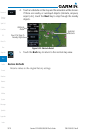
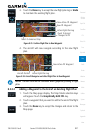
4. Touch the Up or Down keys or touch the display and drag
your finger to scroll through the list. Touch the desired item
to select it or touch the Back key to cancel selection.
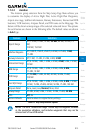
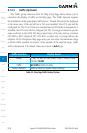
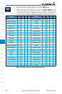
Map Data Field Type
BRG - Bearing to Current Waypoint GSL - GPS Altitude
DIS - Distance to Current Waypoint MSA - Minimum Safe Altitude
DIS to Dest - Distance to Destination OAT (static) - Static Air Temperature
DTK - Desired Track OAT (total) - Total Air Temperature
ESA - Enroute Safe Altitude Time - Current Time
ETA - Estimated Time of Arrival TKE - Track Angle Error
ETA at Dest - ETA at Destination Trip Timer - Timers (Utilities)
ETE - Estimated Time Enroute TRK - Track
ETE to Dest- ETE to Destination VSR - Vertical Speed Required
Fuel Flow - Total Fuel Flow Wind - Wind Speed and Direction
Generic Timer - Timers (Utilities) XTK - Cross Track Error
GS - GPS Ground Speed OFF - Do Not Display Data Field
Table 8-6 Map Data Field Types of Information