


14-18
Garmin GTN 625/635/650 Pilot’s Guide
190-01004-03 Rev. B
Foreword
Getting
Started
Xpdr Ctrl
Com/Nav
FPL
Direct-To
Proc
Wpt Info
Map
Traffic
Terrain
Weather
Nearest
Music
Utilities
System
Messages
Symbols
Appendix
Index
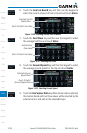
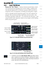
14.5 Fuel Planning
Fuel Planning — When equipped with fuel flow (FF) and/or fuel on
board (FOB) sensors, this item displays fuel conditions along the active
direct-to or flight plan. You may also manually enter fuel flow, ground
speed (GS) and (in some instances) fuel on board figures for planning
purposes. Fuel planning figures can be displayed not only for the currently
active flight plan or direct-to, but also point-to-point between two specified
waypoints and for any programmed flight plan. Fuel planning figures can
be entered and displayed based upon one of three configurations:
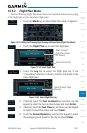
•No Fuel Sensors Connected — In this instance fuel on board and fuel flow
are manually entered in the unit start-up sequence and used to recalculate
fuel on board as it is consumed. When fuel flow or fuel on board is manually
entered, the figures are retained the next time you view the page (with fuel
on board continuously recalculated).
•Fuel Flow Sensor Installed, But No Fuel On Board Sensor — Fuel on board is
manually entered. Fuel flow is automatically provided by sensor. If fuel flow
is manually entered (to override the sensor), it does not affect the FOB figure
and is not retained the next time you view the page.
•Fuel Flow and Fuel On Board Sensors Installed — Fuel flow and fuel on
board are automatically provided by sensors. Fuel on board can NOT be
entered manually. Fuel Flow can be entered manually, but does not affect the
FOB figure and is not retained the next time you view the page.
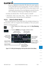
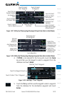
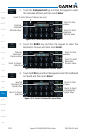
14.5.1 Point-To-Point Mode
The Fuel Planning Point-to-Point mode shows fuel calculations between two
selected points: either two waypoints from the database or from your present
position to a selected waypoint.
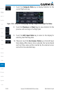
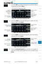
1. While viewing the Utilities page, touch the Fuel Planning
key.
2. Touch the Mode key to toggle to Point-to-Point, if required.
3. Touch the P.POS key to toggle between using your present
position as the From waypoint when selected or a waypoint
selected from the database when P.POS is deselected. If P.POS
is selected, the Lat/Lon of the present position will be shown
in the From position.