


8-1190-01004-03 Rev. B
Garmin GTN 625/635/650 Pilot’s Guide
Foreword
Getting
Started
Xpdr Ctrl
Com/Nav
FPL
Direct-To
Proc
Wpt Info
Map
Traffic
Terrain
Weather
Nearest
Music
Utilities
System
Messages
Symbols
Appendix
Index
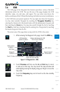
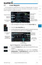
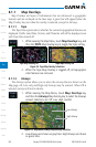
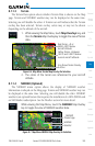
8 MAP
The Map page is used to provide situational awareness in flight. The Map
page can display the following information:
•Airports, NAVAIDs, airspace,
airways, land data (highways,
cities, lakes, rivers, borders, etc.)
with names
•Wind direction and speed
•Iconsforenabledmapfeatures
•Aircraft icon (with the nose
representing present position)
•Navrangering
•Flightplanlegs
•Topographyscale
•Topographydata
•XMNEXRADWeather(Optional)
•TerrainOverlay
•TrafcOverlay
Back to
Previous Page
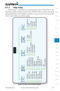
Range Keys
Touch to Zoom
In and Out
Aircraft Symbol
(Present Position)
Active Flight
Plan Leg
Map Orientation
Map Menu
Options
North Indicator
Map Scale
Nav Range Ring
Figure 8-1 Map Page Description
NOTE: The electronic map is an aid to navigation and is designed to
facilitate the use of authorized government charts, not replace them.
Land and water data is provided only as a general reference. The accuracy
of the land and water data is not suitable for use as a primary source of
navigation and should only be used to supplement official government
charts and notices.