


8-31190-01004-03 Rev. B
Garmin GTN 625/635/650 Pilot’s Guide
Foreword
Getting
Started
Xpdr Ctrl
Com/Nav
FPL
Direct-To
Proc
Wpt Info
Map
Traffic
Terrain
Weather
Nearest
Music
Utilities
System
Messages
Symbols
Appendix
Index
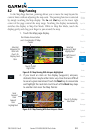
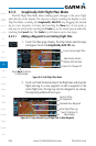
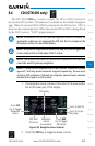
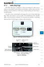
8.6 Map Symbols
Various symbols are used to distinguish between waypoint types. The
identifiers for any on-screen waypoints can also be displayed. Special-use and
controlled airspace boundaries appear on the map, showing the individual
sectors in the case of Class B, Class C, or Class D airspace. The following symbols
are used to depict the various airports and navaids on the Map Page:
Symbol
Description
Airport with hard surface runway(s); Serviced, Primary runway shown
Airport with hard surface runway(s); Non-Serviced, Primary runway
shown
Airport with soft surface runway(s) only, Serviced
Airport with soft surface runway(s) only, Non-Serviced
Unknown Airport
Restricted (Private) Airfield
Intersection
VOR
VORTAC
VOR/DME
TACAN
DME
NDB
Locator Outer Marker
Heliport
Table 8-8 Map Symbols