


8-12
Garmin GTN 625/635/650 Pilot’s Guide
190-01004-03 Rev. B
Foreword
Getting
Started
Xpdr Ctrl
Com/Nav
FPL
Direct-To
Proc
Wpt Info
Map
Traffic
Terrain
Weather
Nearest
Music
Utilities
System
Messages
Symbols
Appendix
Index
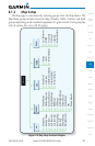
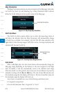
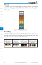
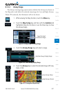
TOPO Scale
The Topo Scale option selects whether the elevation scale for topographical
features on the Map page is displayed. The scale will be located on the right side
of the display.
Figure 8-17 Map Page Topo Scale
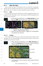
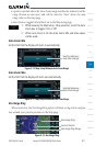
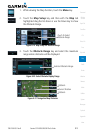
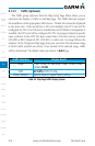
Obstacle Range
The Obstacle Data option selects whether the Obstacle Data is shown on the
Map page. Obstacles will be shown at and below the selected map range. Map
ranges above this value will not show the Obstacle Data.
Unlighted Obstacle
(Height is less than
1000 ft AGL)
Lighted Obstacle
(Height is less
than 1000 ft AGL)
Unlighted Obstacle
(Height is greater
than 1000 ft AGL)
Lighted Obstacle
(Height is greater than
1000 ft AGL)
Figure 8-18 Navigation Map Obstacle Icons