


8-15190-01004-03 Rev. B
Garmin GTN 625/635/650 Pilot’s Guide
Foreword
Getting
Started
Xpdr Ctrl
Com/Nav
FPL
Direct-To
Proc
Wpt Info
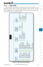
Map
Traffic
Terrain
Weather
Nearest
Music
Utilities
System
Messages
Symbols
Appendix
Index
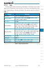
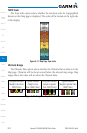
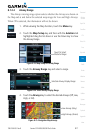
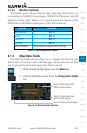
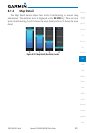
7.1.2.2 Aviation
The Aviation group selection from the Map Setup Page Menu allows you
to customize the display of Active Flight Plan, Active Flight Plan Waypoints,
Airport size range, SafeTaxi information, Runway Extensions, Intersection/NDB
locations, VOR locations, Airspace Detail, and TFR icons on the Map page. The
feature will be shown at map ranges of the selected value and lower. The options
for each feature are shown in the following table. The default values are shown
in bold type.
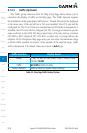
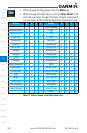
Feature Selection
Airport Range
Off, 7.5 NM, 10 NM, 15 NM, 25 NM, 40 NM, 50 NM, 75
NM,
100 NM, 150 NM
SafeTaxi Diagrams
Off, 1000 ft, 1500 ft, 2500 ft, 0.5 NM, 0.75 NM, 1 NM,
1.5 NM
Runway Extensions Off, 1 NM, 1.5 NM, 2.5 NM, 4 NM, 5 NM
Intersection Range
Off, 0.75 NM, 1 NM, 1.5 NM, 2.5 NM, 4 NM, 5 NM, 7.5 NM,
10 NM
NDB Range
Off, 0.75 NM, 1 NM, 1.5 NM, 2.5 NM, 4 NM, 5 NM,
7.5 NM, 10 NM
VOR Range
Off, 10 NM, 15 NM, 25 NM, 40 NM, 50 NM, 75 NM,
100 NM
User Wpt Range
Off, 0.75 NM, 1 NM, 1.5 NM, 2.5 NM, 4 NM, 5 NM, 7.5 NM,
10 NM, 15 NM, 25 NM, 40 NM, 50 NM, 75 NM, 100 NM
Airspace Detail None, Least, Less, Normal, More, Most
Airway Range 2.5 NM, 4 NM, 5 NM, 7.5 NM, 10 NM, 15 NM, 25 NM
TFRs Off, On
Restore Defaults Returns values to original factory settings
Table 8-2 Map Setup Aviation Options
NOTE: The term “intersection range” means any GPS waypoint included
in the navigation database, and includes waypoints that may not be
intersections of two VOR radials.