


8-6
Garmin GTN 625/635/650 Pilot’s Guide
190-01004-03 Rev. B
Foreword
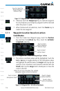
Getting
Started
Xpdr Ctrl
Com/Nav
FPL
Direct-To
Proc
Wpt Info
Map
Traffic
Terrain
Weather
Nearest
Music
Utilities
System
Messages
Symbols
Appendix
Index
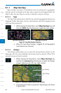
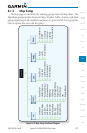
8.1.1.5 StormScope
®
(Optional)
The WX-500 StormScope Weather Mapping Sensor is a passive weather
avoidance system that detects electrical discharges associated with thunderstorms
within a 200 NM radius of the aircraft. The StormScope measures relative
bearing and distance of thunderstorm-related electrical activity and reports the
information to the display.
NOTE: Refer to the WX-500 Pilot’s Guide for a detailed description of the
WX-500 StormScope.
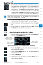
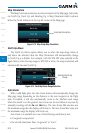
1. While viewing the Map Menu, touch the StormScope Map
Overlay key to toggle the view of StormScope radar weather
data.
2. StormScope data will be overlayed on the Map page. See the
Weather section for more details.
Icon Shows StormScope
Overlay Is Active
Figure 8-8 Map Menu StormScope Map Overlay On Selection
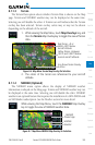
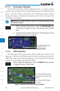
7.1.1.6 Traffic (Optional)
The Traffic Map Overlay option selects whether Traffic data is shown on the
Map page. A Traffic icon will indicate that the Traffic overlay has been selected.
Traffic may or may not be shown depending on the other aircraft's location and
equipment. See the Traffic section for more detail.
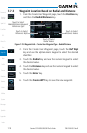
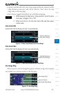
While viewing the Map Menu, touch the Traffic Map Overlay key
to toggle the view of Traffic data.
Non-Threat Traffic Indication.
Currently 1200 Ft Above And
Rising
Icon Shows Traffic Overlay
Is Active
Figure 8-9 Map Menu Traffic Map Overlay On Selection