


8-22
Garmin GTN 625/635/650 Pilot’s Guide
190-01004-03 Rev. B
Foreword
Getting
Started
Xpdr Ctrl
Com/Nav
FPL
Direct-To
Proc
Wpt Info
Map
Traffic
Terrain
Weather
Nearest
Music
Utilities
System
Messages
Symbols
Appendix
Index
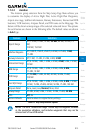
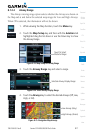
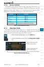
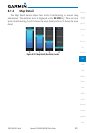
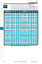
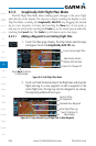
1. While viewing the Map page, touch the Menu key.
2. While viewing the Map Menu, touch the Map Detail scale
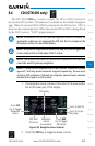
and slide your finger to adjust the level. Features marked with
a • are shown at the indicated Map Detail (Declutter) Level.
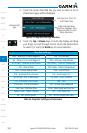
Feature 0 1 2 3 Feature 0 1 2 3
Class D Airspace • •
River/Lake Names • Tower • •
Land/Country Text • TRSA • •
Large City • ADIZ • •
Medium City • Alert Areas • •
Small City • Caution Areas • •
Small Town • Danger Areas • •
Freeways • Warning Areas • •
Highways • Large Airports • • •
Roads • Medium Airports • • •
Railroads • Prohibited Areas • • •
Political Boundaries • MOAs • • •
User Waypoints • • Runway Labels • • •
Lat/Lon Grids • •
Lightning Strike Data
• • •
VORs • • NEXRAD Data • • •
NDBs • • Traffic Symbols • • •
Intersections • • Traffic Labels • • •
Class B Airspace • • Water Detail • • • •
Class C Airspace • • Active FPL Legs • • • •
Airways • • • •
Table 8-7 Features Shown at Each Map Detail Level